School subject: Physical Education and Sports
Topic: Orienteering
Grade: 10th Grade
Number of hours: 2 school hours
Author: Alexandre Pinto
Short description:
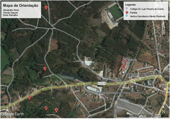
The lesson is designed to be performed during regular sports classes with 10th grade students. Classes will be combined in the IT classroom and the school's immediate surroundings. Students will have to learn to read a map and divide into groups. Each group will be responsible for choosing a place to place a goal. In the end, we will merge all the beacons into a single map. The practical class will consist of a race against time. The group that completes the course in the shortest time will be the winner.
During the race, students will have access to the map through their cell phones.
Learning objectives:
- Learn to use maps for location and displacement;
- Practice physical activity in contact with nature;
- Use auxiliary means, namely computers, to support location tasks and geopositioning devices.
- Recognize different itineraries identification models, as well as some national and international buoyant codes.
Process:
What is Orienteering:
Orienteering is the sport of navigation, using a highly detailed map. Whether you’re an experienced hiker, competitive runner, or just a family or group out for an activity in a park, this sport helps you improve your navigation each time.
Orienteering can gradually build your map-reading skills from exploring a local city park full of obvious structures to navigating remote terrain with few, if any, man-made features.
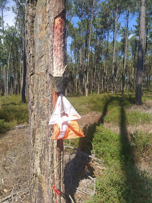
On orienteering maps, a course consists of a triangle, circles, a double circle and sometimes connecting lines all in purple. The triangle is the start. The double circle is the finish. All the circles in between are checkpoints. Numbered orange and white flags are placed in the terrain to show you that you have reached the correct location. At each checkpoint you will punch registering that you found the correct location. You may use any route you want between checkpoints.
For all participants, the structure of an event is a safety function. At the end of the event, the number of returnees needs to match the number who started, so always check in with the finish line volunteers, even if you don’t complete your course. This keeps the sport safe and fun.
Orienteering maps are drawn to a large scale when compared to most topographic maps. Most commonly they are 1:15000 (1cm=150m) or 1:10000 (1cm=100m) but for orienteering in parks you use a map drawn in a scale of 1:5000. All maps use an internationally agreed set of symbols and these are logical and easy to learn. You should absorb much of the information simply by attending your first few events. Most orienteering maps will also provide a detailed legend to help you understand the map.
Proofs (photos):