Seismicity of Romania
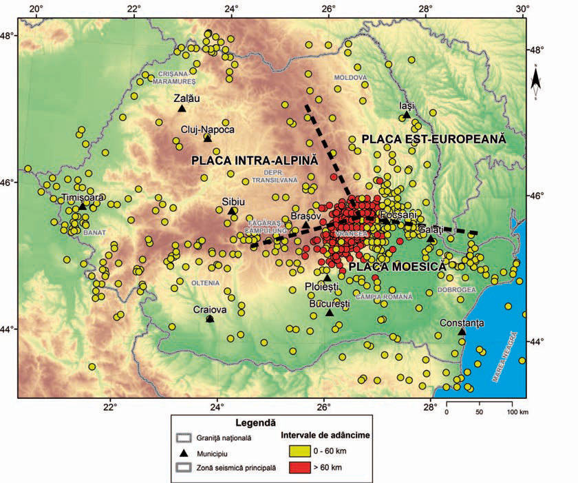
Seismicity of Romania is clustered in several epicentral zones: Vrancea, Făgăraş - Câmpulung, Banat, Crişana, Maramureş and Dobrogea. Other epicentral zones of local importance can be found in Transylvania, in the area of Jibou and Tarnava river, in northern and western part of Oltenia, in northern Moldova and in the Romanian Plain.
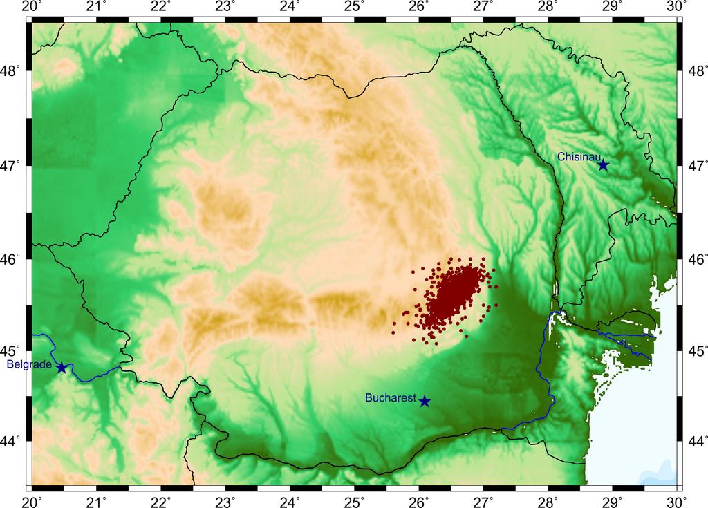
The Vrancea seismogenic zone is the most important among these seismic zones, having in mind the energy, the extent of the macroseismic effects and the persistent and confined character of the earthquakes that occur in this area.

The seismogenic zones of Romania
1. Intermediate – depth seismic zone
Vrancea subcrustal Zone (VR)
The most dangerous seismogenic zone in Romania is located in the subcrustal lithosphere at the bending of the Eastern Carpathians – Vrancea region.

2. Shallow-depth seismic areas
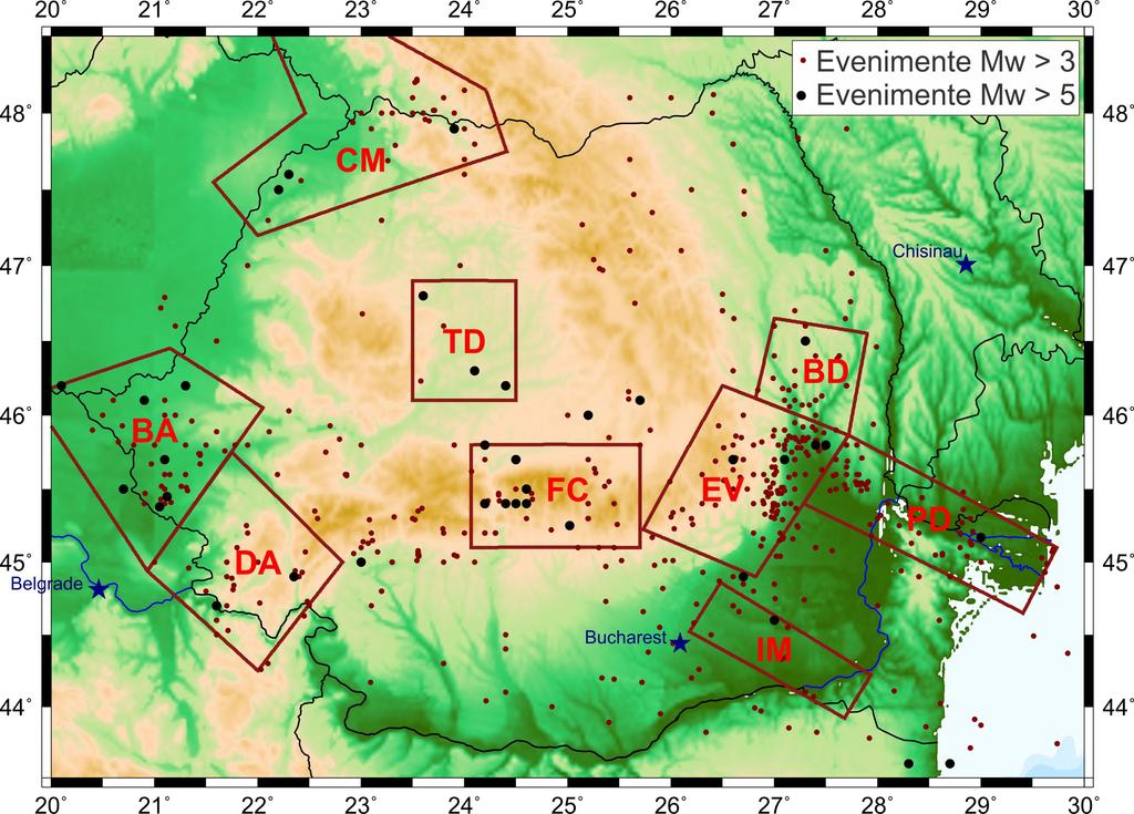
Beside this intermediate-depth source, several shallow-depth seismic areas of local importance for the seismic hazard are pointed out: the East-Vrancea, Făgăraş – Câmpulung, Danubian, Banat and Crişana – Maramureş zones, the Bârlad Depression, the Predobrogean Depression, the Intramoesian Fault, and the Transylvanian Depression.

East Vrancea Zone (EV)
The shallow seismicity in the Vrancea region spreads diffusely eastward relative to the Carpathians arc bend. It consists of only moderate-size earthquakes, not exceeding magnitude 6. Bursts of seismic activity – earthquake sequences or swarms – are relatively common in this zone (e.g., in Râmnicu Sărat – Focşani region, in Vrâncioaia area).
Făgăraş – Câmpulung Zone (FC)
The Făgăraş – Câmpulung zone is sited in the eastern part of the Southern Carpathians. It is characterized by shocks as large as Mw~6.5, which are the largest shallow earthquakes recorded on the Romanian territory. The last major event occurred on January 26, 1916 (Mw=6.4), and was followed by significant aftershock activity.
The epicenter distribution outlines two clusters: one located to the west, which includes the largest shocks (Mw~6), the other one located to the east (Sinaia region), with smaller events (Mw<5).
Danubian Zone (DA)
The seismogenic Danubian Zone represents the western extremity, adjacent to the Danube river, of the orogenic unit of the Southern Carpathians.
The rate of seismic activity is relatively high, especially at the border and beyond the border with Serbia, across the Danube river. The magnitude does not exceed 5.6.
Banat Zone (BA)
The contact between the Panonnian Depression and the Carpathian orogen lies entirely along the western part of the Romanian border.
Two enhancements in the seismicity distribution were identified, in two relatively distinct active areas: Banat to the south, and Crişana-Maramureş to the north, although no significant tectonic or geostructural differences can be noticed between them.
The seismicity of the Banat zone is characterized by many earthquakes with magnitude Mw>5, but not exceeding 5.6. In general, the larger shocks, which are frequently followed by aftershock sequences, occur in clusters (within a few month intervals).
Crişana-Maramureş Zone (CM)
The historical earthquake catalogues report the occurrence of events greater than magnitude 6 in Crişana-Maramureş. Several damaging earthquakes with magnitude above 5 are also reported on the basis of historical information. During the instrumental period (starting with the XXth century), however, only one event approaching magnitude 5 has been localized in the zone.
Bârlad Depression (BD)
The Bârlad Depression is a subsiding depression situated to the NE of the Vrancea region on the Scythian platform, and it represents the prolongation towards the NW of the Predobrogean Depression. Only moderate-size events are observed, not exceeding Mw=5.6.
Predobrogean Depression (PD)
This seismogenic zone belongs to the southern margin of the Predobrogean Depression, following the Sfântul Gheorghe fault alignment.
Roughly, the seismicity and focal mechanism characteristics are similar to those outlined for the Bârlad Depression: the moderate seismic activity (Mw≤5.3), clustered especially along the Sfantul Gheorghe fault, and the extensional regime of the deformation field. This consistently reflects the affiliation of the two zones to the same tectonic unit – the Scythian platform.
Intramoesian Fault (IM)
The Intramoesian fault crosses the Moesian platform in a SE–NW direction, separating two distinct sectors with different constitution and structure of the basement. Although it is a well-defined deep fault, reaching the base of the lithosphere and extending southeast to the Anatolian fault region, the associated seismic activity is scarce and weak (only two events above magnitude 5, both reported in the instrumental period).
Transylvanian Depression (TD)
This seismogenic zone is defined only on the basis of historical information.
The seismic activity is mostly absent at present; nevertheless, several earthquakes with magnitude above 5 (a couple of events with Mw > 5.5) have been reported on the basis of historical documents, which notify important damaging effects in Transylvania.
References: http://www.infp.ro/en/seismic-areas/
The seismogenic zones of Romania

NATIONAL CAMPAIGN FOR INFORMATION AND TRAINING OF POPULATION about earthquakes
HOW (UN)READY ARE YOU FOR AN EARTHQUAKE?