Eruptions in Greece
Minoan eruption-Santorini eruption
The Minoan eruption of Thera, also referred to as the Thera eruption or Santorini eruption, was a major catastrophic volcanic eruption with a Volcanic Explosivity Index (VEI) of 6 or 7 and a dense-rock equivalent (DRE) of 60 km3 (14 cu mi), Dated to the mid-second millennium BCE , the eruption was one of the largest volcanic events on Earth in recorded history. It devastated the island of Thera (now called Santorini), including the Minoan settlement at Akrotiri and communities and agricultural areas on nearby islands and the coast of Crete with a related earthquake or tsunami.
There are no clear ancient records of the eruption, which may have inspired certain Greek myths, caused turmoil in Egypt and be alluded to in a Chinese chronicle.
Background
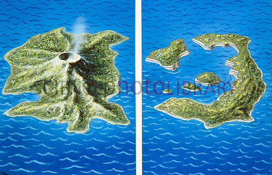
Geological evidence shows the Thera volcano erupted numerous times over several hundred thousand years before the Minoan eruption. In a repeating process, the volcano would violently erupt, then eventually collapse into a roughly circular seawater-filled caldera, with numerous small islands forming the circle. The caldera would slowly refill with magma, building a new volcano, which erupted and then collapsed in an ongoing cyclical process .
Immediately prior to the Minoan eruption, the walls of the caldera formed a nearly continuous ring of islands with the only entrance lying between Thera and the tiny island of Aspronisi . This cataclysmic eruption was centered on a small island just north of the existing island of Nea Kameni in the centre of the then-existing caldera. The northern part of the caldera was refilled by the volcanic ash and lava, then collapsed again.
Sequence
On Santorini, there is a 60 m (200 ft) thick layer of white tephra that overlies the soil clearly delineating the ground level prior to the eruption. This layer has three distinct bands that indicate the different phases of the eruption. Studies have identified four major eruption phases, and one minor precursory tephra fall. The thinness of the first ash layer, along with the lack of noticeable erosion of that layer by winter rains before the next layer was deposited, indicate that the volcano gave the local population a few months' warning. Since no human remains have been found at the Akrotiri site, this preliminary volcanic activity probably caused the island's population to flee. It is also suggested that several months before the eruption, Santorini experienced one or more earthquakes , which damaged the local settlements.
Geomorphology
Although the fracturing process is not yet known, the altitudinal statistical analysis indicates that the caldera had formed just before the eruption. The area of the island was smaller, and the southern and eastern coastlines appeared regressed. During the eruption, the landscape was covered by the pumice sediments. In some places, the coastline vanished under thick tuff depositions. In others, recent coastlines were extended towards the sea. After the eruption, the geomorphology of the island was characterized by an intense erosional phase during which the pumice was progressively removed from the higher altitudes to the lower ones.
Climatic effects
Hydrogeologist Philip LaMoreaux asserted in 1995 that the eruption caused significant climatic changes in the eastern Mediterranean region, Aegean Sea and much of the Northern Hemisphere, but that was forcefully rebutted by volcanologist David Pyle a year later.
Around the time of the radiocarbon-indicated date of the eruption, there is evidence for a significant climatic event in the Northern Hemisphere like failure of crops in China and evidence from tree rings , cited above: bristlecone pines of California; bog oaks of Ireland, England, and Germany; and other trees in Sweden. The tree rings precisely date the event to 1628 BCE.
Video : https://www.youtube.com/watch?v=BsJekC5QiFM (3.31 min.)