A trip do Landscapes and biodiversity
Challenge for Team 3
Students will use Google tour builder to create a trip through landscapes and biodiversity.
If you want to add a landscape image, add it under the heading "example of one landscape".
If you want to add a biodiversity image, add it under the heading "example of one biodiversity".
See this example https://tourbuilder.withgoogle.com/tour/ahJzfmd3ZWItdG91cmJ1aWxkZXJyEQsSBFRvdXIYgICg6tP8zQoM
This team will create a tour through the Landspace and Biodiversity of partners countries. Before adding the final information to the Tourbuilder partners need to validade information. They need to be checked and confirmed by partners before it is in the final version.
Copy and paste this ==========================================================================
Team X : students name
Name:
Country and place:
GPS coordinates, latitude and longitude with Google Maps:
World heritage (Y/N):
Description:
Source:
Photo:
Review by:
===================================================================================
Team 3: Nuno Custódio
Name: Vanoise National Park - " Parc National de la Vanoise "
Country and place: France, Vanoise National Park
GPS coordinates, latitude and longitude with Google Maps: 45°20′N 6°50′E
World heritage (Y/N): N
Description: The park is well known for its population of Alpine ibex.The alpine chamois, like the ibex, spend most of the year above the tree line. They descend the snow line in early spring and late fall to enjoy the grass uncovered by the ice and snow.
Source: https://goo.gl/Ag45JH
Copy short URL
Photo: 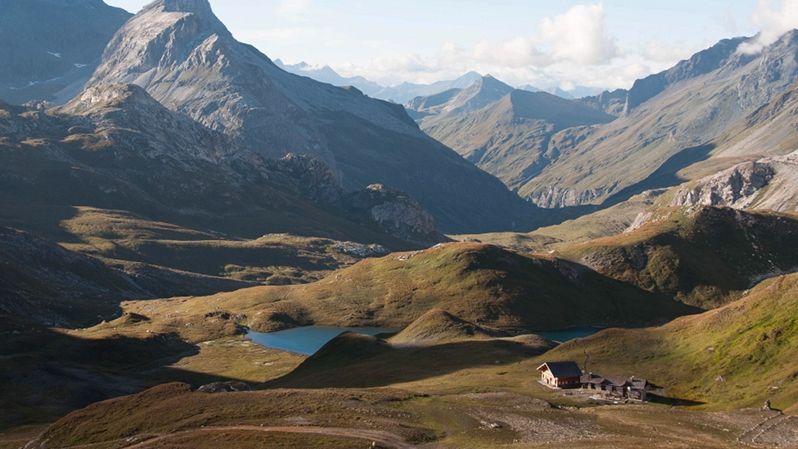
Review by:This information added before, Please add another Landscape(Cihat OTU)...
We didn ´t find it before. Where did you had it before?
===================================================================================
Team 3: Paulo Bastos
Name: Pamukkale
Country and place: Turkey, Denizli
GPS coordinates, latitude and longitude with Google Maps: 37°55′23″N 29°07′26″E
World heritage (Y/N):
Description: Pamukkalein is a natural place in Denizli in southwestern Turkey. The area is famous for a carbonate mineral left by the flowing water. It is located in Turkey's Inner Aegean region, in the River Menderes valley.
Source: https://bit.ly/1GhcANR
Photo: https://bit.ly/2v1Qa9L
Review by: This is Great (Meriç Yarıkkaya)
Example of one landspace=============================================
Team 3: name
Name: Lagoa das Sete Cidades - "Lagoon of the Seven Cities"
Country and place: Azores, Portugal
GPS coordinates, latitude and longitude with Google Maps: 37° 52' N 25° 47' O
World heritage (Y/N): No
Description: A twin lake situated in the crater of a dormant volcano on the Portuguese archipelago of the Azores. It consists of two small, ecologically different lakes connected by a narrow strait, which is crossed by a bridge. The volcano is located on the western third of the island of São Miguel. The Lagoa das Sete Cidades part of a natural landscape of communitarian interest: it is the largest body of water in the region and one of the most important freshwater resources in the archipelago.
Source: https://goo.gl/srB4DN
Photo: https://goo.gl/xTx8bq
Review by:
===================================================================================
Team 3: Laura Sempere
Name: Benagil Beach
Country and place: Portugal, Lagoa
GPS coordinates, latitude and longitude with Google Maps: 37° 05′ N 8° 25′ W
World heritage (Y/N): No
Description: It is a hidden beach inside a cave that surrounds it, it can only be accessed through the sea, with kayak or boat.
Source: http://goo.gl/bXmYxW
Photo: http://goo.gl/xM5WGu
Review by:Paulo (Team 3)
===================================================================================
Team 3: Laura Sempere
Name: Cliffs of Etretat
Country and place: France, Étretat
GPS coordinates, latitude and longitude with Google Maps:
World heritage (Y/N): No
Description: Étretat is well known for its cliffs, including a very famous natural arch, the Porte d'Aval and the rock pillar called L 'Aiguille Creuse.
Source: http://goo.gl/YMPE8w
Photo: http://goo.gl/kTT4Wv
Review by:
===================================================================================
Team 3: José Roda
Name: Forêt des Landes, "Forest of the Landes".
Country and place: France, Aquitania
GPS coordinates, latitude and longitude with Google Maps:
World heritage (Y/N): No
Description: The forest composed of maritime pine. This massive pine plantation was started to stop erosion and clean the soil.
Source: https://goo.gl/oMrN1b
Photo: https://goo.gl/UGyUAf
Review by: Every country needs at least a big forest. Green means life! (Jiyan Beşeren)
===================================================================================
Team 3 : Meriç Yarıkkaya
Name: Nemrut Mountain
Country and place: Adıyaman/Turkey
GPS coordinates, latitude and longitude with Google Maps:
World heritage (Y/N): yes
Description: The grave, monumental sculptures and unique landscape of the Antiquech I of Antiochos, King of Kommagene, who ruled on the slopes of Mount Nemrut at 2150 meters high in Kahta District of Adıyaman, is one of the most spectacular remains of the Hellenistic Period. Monumental sculptures spread to the eastern, western and northern terraces. The eastern terrace is the sanctuary and for this reason the most important sculptures and architectural remains are here. The well preserved giant sculptures are made of limestone blocks and are 8-10 meters high.The tomb of the king, with its being known, has not yet been discovered
Source: https://whc.unesco.org/en/list/448
Photo: https://whc.unesco.org/uploads/thumbs/site_0448_0010-750-0-20140708162215.jpg
Review by:
===================================================================================
Team 3 : Ali Çelebi
Name: Alhambra
Country and place: Spain
GPS coordinates, latitude and longitude with Google Maps:
World heritage (Y/N): yes
Description: The Alhambra is a palace and fortress complex located in Granada, Andalusia, Spain. It was originally constructed as a small fortress in AD 889 on the remains of Roman fortifications, and then largely ignored until its ruins were renovated and rebuilt in the mid-13th century by the Nasrid emir Mohammed ben Al-Ahmar of the Emirate of Granada, who built its current palace and walls. It was converted into a royal palace in 1333 by Yusuf I, Sultan of Granada. After the conclusion of the Christian Reconquista in 1492, the site became the Royal Court of Ferdinand and Isabella (where Christopher Columbus received royal endorsement for his expedition), and the palaces were partially altered in the Renaissance style. In 1526 Charles I & V commissioned a new Renaissance palace better befitting the Holy Roman Emperor in the revolutionary Mannerist style influenced by Humanist philosophy in direct juxtaposition with the Nasrid Andalusian architecture, but it was ultimately never completed due to Morisco rebellions in Granada.
Source: https://whc.unesco.org/en/list/314
Photo: https://whc.unesco.org/uploads/thumbs/site_0314_0022-750-0-20151105153009.jpg
Review by:
===================================================================================
Team 3 : Ali Çelebi
Name: Mont Saint-Michel
Country and place: France
GPS coordinates, latitude and longitude with Google Maps: 48 ° 38′10 ″ N 1 ° 30′41 ″ W
World heritage (Y/N): no
Description: Le Mont Saint-Michel is an island commune in Normandy, France. It is located about one kilometre (0.6 miles) off the country's northwestern coast, at the mouth of the Couesnon River near Avranches and is 100 hectares (247 acres) in size. As of 2009, the island has a population of 44.The island has held strategic fortifications since ancient times and since the 8th century AD has been the seat of the monastery from which it draws its name. The structural composition of the town exemplifies the feudal society that constructed it: on top, God, the abbey and monastery; below, the great halls; then stores and housing; and at the bottom, outside the walls, houses for fishermen and farmers.The commune's position — on an island just 600 metres from land — made it accessible at low tide to the many pilgrims to its abbey, but defensible as an incoming tide stranded, drove off, or drowned would-be assailants. The Mont remained unconquered during the Hundred Years' War; a small garrison fended off a full attack by the English in 1433. The reverse benefits of its natural defence were not lost on Louis XI, who turned the Mont into a prison. Thereafter the abbey began to be used more regularly as a jail during the Ancien Régime
Source: https://en.wikipedia.org/wiki/Le_Mont_Saint-Michel
Photo:
Review by:
===================================================================================
Team 3: Ethem GÜNHAN
Name: "Flegere Lake Reflections"
Country and place: France, Bonneville
GPS coordinates, latitude and longitude with Google Maps: https://goo.gl/CitDGe
World heritage (Y/N): No
Description: Chamonix-Mont-Blanc, more commonly known as Chamonix (formerly spelled Chamounix), is a commune in the Haute-Savoie département in the Auvergne-Rhône-Alpes region in south-eastern France. It was the site of the first Winter Olympics in 1924. The commune's population of around 8,900 ranks 1,089th within the country of France.
Source: goo.gl/Q1VFYH
Photo: goo.gl/yomzA1
Review by:
===================================================================================
Team 3 : Ethem GÜNHAN
Name: "Cabo Vilàn Natural Landscape"
Country and place: Spain, Cabo Vilàn
GPS coordinates, latitude and longitude with Google Maps: http://goo.gl/SrGzMr
World heritage (Y/N): No
Description: In this gallery portfolio you can see the best Cabo vilà landscape pictures taken during the summer months.
Source: http://goo.gl/cSpxh3
Photo: http://goo.gl/cSpxh3
Review by:
===================================================================================
Team 3 : Cihat OTU
Name: Alabaster Coast
Country and place: France,Seine-Maritime
GPS coordinates, latitude and longitude with Google Maps:
World heritage (Y/N): No
Description: Running alongside the Pays de Caux area, the Alabaster coast stretches 130 kilometres. Magnificent white cliffs lined with pebble beaches can be admired between Le Tréport and the Hève cape. Its dizzyingly high chalk cliffs reach 120 metres in places! The long-distance Grande Randonnée footpath running along the top of these sheer cliffs offers exceptional views and will delight hikers. There are several essential stopping places along this magnificent coast, including Étretat, Fécamp and Dieppe.
Source:http://goo.gl/XD35ub
Photo: https://goo.gl/c4SYC1
Review by:
===================================================================================
Team 3 : Cihat OTU
Name: Vanoise National Park
Country and place: France,Savoie
GPS coordinates, latitude and longitude with Google Maps:
World heritage (Y/N): No
Description:Initially created to protect ibexes, the Vanoise national park is today an important site for the protection of flora and fauna. Stretching over 53,000 hectares, this park is divided into two parts: a central area in the heart of the massif for ramblers and skiers only, and an outlying area grouping together the prestigious ski resorts of the Tarentaise area, as well as typical villages. The Vanoise massif comprises around 100 peaks over 3,000 metres in altitude. The striking and unspoiled landscapes of the Vanoise massif are magical and awe-inspiring. Mountain walking fans will be in heaven.
Source: https://goo.gl/wUBYfN
Photo: https://goo.gl/F18Wtq
Review by:
===================================================================================
Team 3 : Cihat OTU
Name: Sierra Nevada
Country and place: Spain,Granada
GPS coordinates, latitude and longitude with Google Maps:
World heritage (Y/N): No
Description:The Sierra Nevada (meaning "snowy mountain range" in Spanish) is a mountain range in the region of Andalucia, in the province of Granada and, a little further, Málaga and Almería in Spain. It contains the highest point of continental Spain and Europe[note 1] outside the Caucasus Mountains and the Alps, Mulhacén at 3,478 metres (11,411 ft) above sea level.
Source: https://bit.ly/2Hxd1Mh
Photo: https://bit.ly/2vOUbP8
Review by:
===================================================================================
Team 3 : Cihat OTU
Name: Cappadocia
Country and place: Turkey,Nevşehir
GPS coordinates, latitude and longitude with Google Maps:
World heritage (Y/N): Yes
Description:Cappadocia, (Cappadocia) 60 million years ago Erciyes, Hasandağı and Güllüdağ sprayed lava and ashes formed by the soft layers of millions of years of rain and wind erosion emerged by the region.
Source: https://bit.ly/2vL8TGN
Photo: https://bit.ly/2FhCmHR
Review by:
===================================================================================
Team 3 : Meriç Yarıkkaya
Name: Tuz Lake
Country and place: Between Ankara And Aksaray
GPS coordinates, latitude and longitude with Google Maps:
World heritage (Y/N): No
Description: Tuz Lake is located in the Central Anatolia Region where the borders of Ankara, Konya and Aksaray intersect. 40% of Turkey's needs through this salt lake
Source: https://bit.ly/2FTi2ga
Photo: https://bit.ly/2jzCCJO
Review by:
===================================================================================
Team 3 : Meriç Yarıkkaya
Name: Safranbolu Houses
Country and place: Türkey/Safranbolu
GPS coordinates, latitude and longitude with Google Maps:
World heritage (Y/N): Yes
Description: in the province of Safranbolu in the province of karabük, 18th and 19th century Ottoman city life and history are preserved until the day is a county. It was taken by UNESCO on World Cultural Heritage list on 17.12.1998.
Source: https://bit.ly/2KJaIHF
Photo: https://bit.ly/2K28G4l
Review by:
===================================================================================
Team 3 : Jiyan Beşeren
Name: Ölüdeniz
Country and place:(TURKEY) Ölüdeniz sits just south of Fethiye, where the Aegean meets the Mediterranean.
GPS coordinates, latitude and longitude with Google Maps:
World heritage (Y/N): No
Description: One of the most attractive stretches of Turkey’s Turquoise Coast (and that’s saying a lot), the little beach town of Ölüdeniz sits just south of Fethiye, where the Aegean meets the Mediterranean. The pebbly beach swings westward in a gentle crescent, ending at a picturesque blue lagoon that’s protected as a nature reserve. In addition to just sitting back and enjoying this Blue Flag beach, you can also get into paragliding here — Mount Babadağ, just southeast of town, is one of the best launches in Europe — and scuba divers can take advantage of the especially clear water.
Source: http://bit.ly/2wrAJbE
Photo: http://bit.ly/2rxHFxV
Review by:
===================================================================================
Example of one biodiversity=============================================
Team 3 : Ethem GÜNHAN
Name: "Lytta vesicatoria" & "Spanish fly"
Country and place: southern European species
GPS coordinates, latitude and longitude with Google Maps:
World heritage (Y/N): No
Description: Spanish fly is an emerald-green beetle, Lytta vesicatoria, in the blister beetle family (Meloidae). It and other such species were used in preparations offered by traditional apothecaries, often referred to as Cantharides or Spanish fly. The insect is the source of the terpenoid cantharidin, a toxic blistering agent once used as an aphrodisiac.
Source: https://goo.gl/EYYcNM
Photo: https://goo.gl/UMWiUT && https://goo.gl/bcirUa
Review by:
===================================================================================
Team 3 : Cihat OTU
Name: Van Cat
Country and place: Turkey,Van
GPS coordinates, latitude and longitude with Google Maps:
World heritage (Y/N): No
Description: The Van cat (Turkish: Van kedisi) is a distinctive landrace of domestic cat, found in the Lake Van region of eastern Turkey. It is relatively large, has a chalky white coat, sometimes with ruddy coloration on the head and hindquarters, and has blue or amber eyes or is odd-eyed (having one eye of each colour).The variety has been referred to as "the swimming cat", and observed to swim in Lake Van.
Source: https://bit.ly/2Jq9zU0
Photo: https://bit.ly/2HrmrwB
Review by:
===================================================================================
Team 3 : Cihat OTU
Name: Isparta Rose
Country and place: Turkey,Isparta
GPS coordinates, latitude and longitude with Google Maps:
World heritage (Y/N): No
Description: Isparta Rose (Rosa × damascena) is a hybrid rose from Rosa gallica and Rosa moschata species.
Source: https://bit.ly/2HqSDAg
Photo: https://bit.ly/2Jspf9s
Review by:
===================================================================================
Team 3 : Cihat OTU
Name: Hamsi
Country and place: Turkey,Karadeniz
GPS coordinates, latitude and longitude with Google Maps:
World heritage (Y/N): No
Description: The name hamsi is of archaic kolh language and its original prototype means "small pointed fish".Anchovy is a saltwater fish of oseanodrom, which lives in a depth of 400 metres in the subtropical climate seas. It is assumed that the water temperature is 21 °C which is best adapted.Most of them live in the Black Sea, the Azov Sea, the Marmara Sea and the Mediterranean Sea.
Source: https://bit.ly/2FhbmbB
Photo: https://bit.ly/2qXcKMm
Review by:
===================================================================================
Team 3 : Cihat OTU
Name: Kelaynak
Country and place: Turkey,Birecik
GPS coordinates, latitude and longitude with Google Maps:
World heritage (Y/N): No
Description: Kelaynak (Geronticus eremita) is a bird species 70-80 cm long, 120-135 cm long with a slender beak that walks in water or mud in Rocky or semi-desert dry areas.
Source: https://bit.ly/2Khop0a
Photo: https://bit.ly/2HQfqol
Review by:
===================================================================================
Team 3: José Roda
Name: Grey Wolf, "Canis lupus".
Country and place: Eastern of Europe and the Northern of Asia
GPS coordinates, latitude and longitude with Google Maps:
World heritage (Y/N): No
Description: The gray wolf is a species of placental mammal of the order of carnivores.
Source: https://goo.gl/pfohLb
Photo: https://goo.gl/6P4EM9
Review by:
===================================================================================
Team 3 : Jiyan Beşeren
Name: Mediterranean monk seal
Country and place: It lives on only one shore of the East Mediterranean Coast and West Africa.
GPS coordinates, latitude and longitude with Google Maps:
World heritage (Y/N): NO
Description: The size of the Mediterranean Monkfish, which is a marine mammal, varies between 2 meters and 3 meters. The weights are 200 kg. with 300 kg. lt; / RTI & gt; There is no significant difference in height and weight between adult female and male Mediterranean Seals. When viewed from the outside, the distinction between female and male is usually evident from their color. Men usually have dark-tinted colors and there is a distinct white lacquer in the abdominal areas. The teeth are light brown or gray; under the abdomen have lighter colors.
Source: http://bit.ly/2rtn3be
Photo: http://bit.ly/2KMhBYI
Review by:
===================================================================================
TOUR BUİLDER
Team 3 : Jiyan beşeren
The Tour builder:https://tourbuilder.withgoogle.com/tour/ahJzfmd3ZWItdG91cmJ1aWxkZXJyEQsSBFRvdXIYgICguszKqAkM
Review by:
===================================================================================
Landscape and biodiversity
Biodiversity is the diversity of living species present in an environment.
In Portugal we can see different landscapes like mountains, sea or forests. In the mountains many Portuguese bring up animals and grow many plants like corn and wheat.
In Portugal we can see different landscapes like The Azores is highest mountain, labo de Sâo Vicente is coast of sea, or Rio Douro Valley is a landscape that a prefer.
Rio Douro Valley has river long 200 km. The hills that surround the river banks are hand sculpted with terraces lined with grapewines that produce the famous Porto wine and the other wines of the region.
The Douro Valley in the north of Portugal has the best climate and ground to cultivate grapes and wine-producing cultures. The undulating curves of the Douro create a beautiful and dramatic landscape which changes with the seasons and is so special that it was awarded the UNESCO World Heritage status in 2001.
____________________________________________________________________________________________________________________
Students : Bruno and Gustave
Country : Portugal
Landscape and biodiversity
Biodiversity is the diversity of living species present in an environment.
In Portugal we can see different landscapes like mountains, sea or forests. In the mountains many Portuguese bring up animals and grow many plants like corn and wheat.
In Portugal we can see different landscapes like The Azores, the highest mountain, labo de Sâo Vicente, a coast on the Atlantic Ocean, or Rio Douro Valley, a landscape that we prefer.
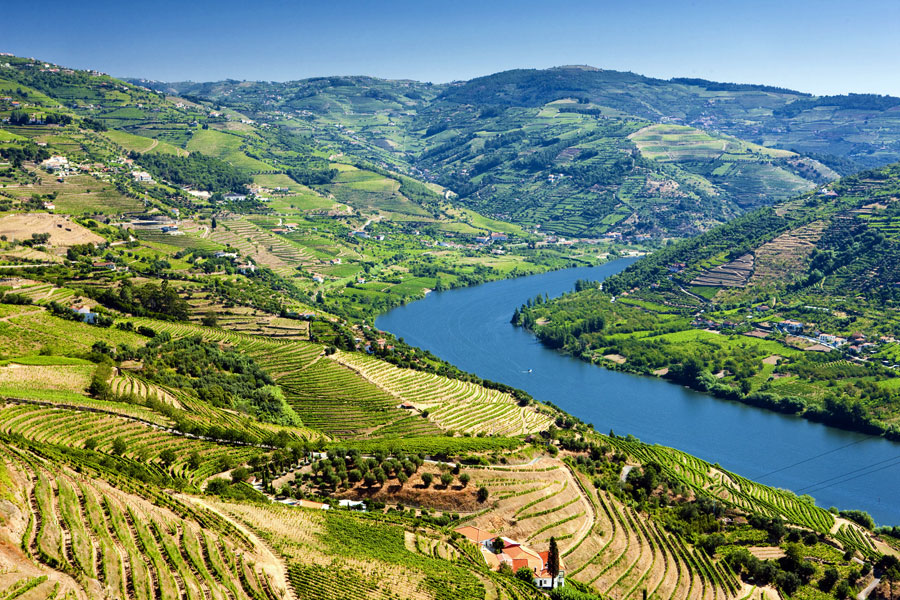
Rio Douro Valley has a river 200 km long. The hills that surround the river banks are hand sculpted with terraces lined with grapewines that produce the famous Porto wine and the other wines of the region.
The Douro Valley in the north of Portugal has the best climate and ground to cultivate grapes and wine-producing cultures. The undulating curves of the Douro create a beautiful and dramatic landscape which changes with the seasons and is so special that it was awarded the UNESCO World Heritage status in 2001.
i