In this activity we will upload photos and info about important geophysical characteristics of our country. We will use Google Maps. You can edit the map using this link:
http://bit.ly/2qwWFzl
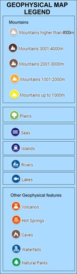
There are the folowing layers on our map
- "Mountains" (mountain icon with colors depending on the height)
- "Plains" (green tree icon)
- "Rivers" (light blue canoe icons)
- "Lakes" (light blue fish icons)
- "Seas" (dark blue icons)
- "Islands" (dark blue boat icons)
- "Other geophysical features" - see legend
- "My hometown" (pink home icon) - Upload the elevation of your hometown and some info/photos of the physical characteristics of your home town (or its surroundings)
Upload info and photo(s) of important mountains and plains, rivers and lakes, Islands and seas (if there are any) and other geophysical features (waterfalls, caves etc) that are around your school or in your country.
Please be carefull that you select the correct layer each time you upload some info, so that there wiil be the correct icon for each feature.
For the mountains, we should use the mountain icon with different colors, depending on their hight, as shown in the map legend.
For the "other geophysical features", use the same icon as in the legend.
If the feature is not in the legend, you can select an appropriate icon of your choice.
Please do not change the icons for the rest of the features (plains, seas etc), because I have selected a uniform icon for each layer and all the pins will change. Just chose the correct layer!
This is a preview of our map:
This activity should be finished by the end of November.
If you or your students are not familiar with Google Maps, you can watch this screencast of how you can add info and photos to the maps.
Video link:
https://youtu.be/HXLpTdpAmNM