TURKEY
KULA VOLCANIC UNESCO GLOBAL GEOPARK
“The region that was ‘fire-born’”
Celebrating Earth Heritage
Kula Volcanic UNESCO Global Geopark is situated in the Aegean Region of Turkey, at Western Anatolia within Manisa Province. The area starts from 200 m in Salihli Town and rises up to 600 m mean elevation in Kula Town. Kula has Mesothermal climate with hot dry summer and cold, rainy winters with rare snow.
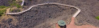
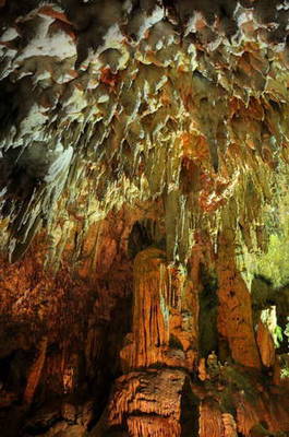
Kula Volcanic UNESCO Global Geopark has a complex geology due to the active tectonic regime in the Aegean extensional province, which is one of the most seismically active and rapidly deforming regions in the world dominated by converging plates, subduction collision related geodynamic process. Kula Volcanic UNESCO Global Geopark rests on the metamorphic basement of the Menderes massif and the ophiolitic mélange units of the İzmir-Ankara Zone, a remnant of the Tethyan Ocean. It represents 200 million years of Earth history from Palaeozoic metamophics to Holocene volcanism. Kula is the youngest volcanic region in Turkey. The Quaternary volcanism in the area formed in three eruptive phases (1.1 million years to 300.000 and 15.000 years ago). The outstanding volcanic structures of the UNESCO Global Geopark area are well known since antique times where the great ancient Greek Geographer Strabo (63 BC-24 AD) in his majestic book “Geographica” named Kula as “KATAKEKAUMENE” (fire-born) because of the coal-black lava.
Sustaining local Communities
Kula Volcanic UNESCO Global Geopark has established a range of facilities and supply services in terms of geotourism and geo-education infrastructure. “Kula Geopark Visitor Centre KATAKEAUMENE” serves as information centre for tourists and as a Natural History Museum for Geo-education activities. It has a bilingual website and leaflets, and more than 12 km of well-organized geotrails connecting the most outstanding geosites, equipped with information panels. It offers guided tours for tourists, indoor and outdoor geo-education activities for school classes. In order to enhance these services and promote scientific research, “JARUM-Geopark Research Centre” was established in collaboration with the Celal Bayar University and the “JPBB-Geopark Municipal Union” and to finance the UNESCO Global Geopark based sustainable local development activities. The UNESCO Global Geopark founded the “GeoCycle” a bicycle society to combine sportive activity with geotourism.
ITALY
CILENTO, VALLO DI DIANO E ALBURNI UNESCO GLOBAL GEOPARK
“The Geopark constitutes a real living landscape that plays an active role in contemporary society”
Celebrating Earth Heritage
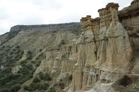
The Cilento, Vallo di Diano e Alburni UNESCO Global Geopark is located in the province of Salerno, Campania and occupies the whole territory of the National Park of the Cilento and Vallo di Diano. The Geopark extends from the Tyrrhenian coast to the margin of the Lucania mountains. In the territory of the Cilento, Vallo di Diano e Alburni UNESCO Global Geopark, the high number of geosites, unique and scientifically valuable, as well as their geodiversity, confirm the consistency of the geological heritage of this area in southern Italy. The area is made up of sedimentary rocks both carbonate and siliciclastic. The Cilento region can be defined as a "Morpho-structural Province", which represents a sub-unit of the larger Campanian-lucanian Tectonic Region. The area belongs to the Southern Apennines fold-and-thrust belt, which developed between late Cretaceous and Pleistocene ages as a consequence of the interaction between the European and the African plates and spreading of the Tyrrhenian oceanic basin. Due to the long and complex lithogenetic and orogenetic history, several litho-stratigraphical units in form of nappes and/or irregular sequences can be distinguished. Such nappes are grouped as internal units and external units, according to the original position before the tectonic deformation. Quaternary postorogenic deposits help us understand the geomorphic processes on the relieves and on the plain and coast, relating also to climatic changes. We can find 130 million years old Mesozoic limestone and dolomite, Mesozoic pelagic deposits and 16-6-million-year-old Miocene siliciclastic turbidite. These rocks represent a key in the evolution of the central Mediterranean.
Moreover, several endemic animals, such as the wolf and otter, have been protected since 1997 by the “Man and Biosphere” programme of UNESCO.
Sustaining local Communities
Since 1998 the archaeological sites of Paestum and Velia and the monumental assets of Chartreuse in Padula have been recognized as World Heritage by UNESCO. More recently, in 2010, UNESCO recognized the Mediterranean diet as intangible heritage of humanity. The countries that submitted a project for this award were Italy, Greece, Spain and Morocco, and the National Park of Cilento and Vallo di Diano represented Italy. In this context, rich in other significant natural and cultural features, one can find attractive routes, where the geological heritage can be connected with the life of nature and human history.
The annual program of environmental education in the schools of the Cilento, Vallo di Diano e Alburni UNESCO Global Geopark has the purpose to introduce the young generations to environmental problems helping them to understand the values of the territory in which they live and the necessary actions for the correct maintenance and fruition. Projects for popularisation have been planned to integrate excursions to the territory into this school program to provide direct knowledge of the natural beauties and particularly of the geo-diversity in the area. The educational program is divided into modules and learning units, and includes a number of proposals for environmental education, differentiated by themes and targets: biodiversity, geodiversity, landscape, sustainable development, nutrition education, sports & nature.
Every year the UNESCO Global Geopark organizes a special Award for students. In the last two education programmes the UNESCO Global Geopark sponsored the visit (transport and tickets) in particular to geosites and museums, to promote the knowledge about the UNESCO Global Geopark.
CROATIA
PAPUK UNESCO GLOBAL GEOPARK
“At first glance, the pillars at Rupnica appear made by man, yet they are the work of a cooling volcano”
Celebrating Earth Heritage
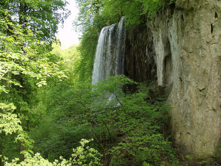
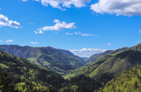
Papuk UNESCO Global Geopark is located in Slavonia, in eastern Croatia. The lowland area of Slavonia is mostly flat agricultural landscape while the Slavonian Mountains reach up to nearly 1000 m high. The UNESCO Global Geopark encompasses the whole territory of the Papuk Nature Park, a protected area since 1999. Mt. Papuk is generally spreading out in an East – West direction and abounds with springs and streams. The highest peak is Papuk (953 m). Papuk's ridge presents the watershed between the Drava catchments area (in the north) and the Sava catchments area (in the south).
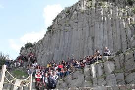
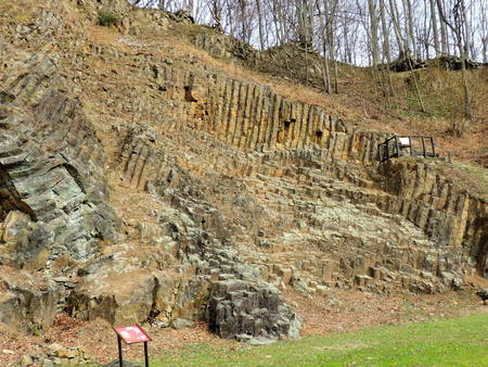
Papuk is the most prominent of the Slavonian Mountains and shows exceptional geological diversity and complex evolution. Mount Papuk has a “stormy” geological history going as far back as the Precambrian with metamorphic rocks that date back as far as the Pre-Cambrian, more than 540 million years ago. More recent geological features result from mountain building with Mesozoic sediments 260 and 65 million years old, including carbonate rocks, mostly dolomites, numerous karst phenomena like sinkholes, caves, speleothems, caverns, springs etc. as well as the Cretaceous volcanic sedimentary complex of Rupnica which was protected as Croatia’s first natural geological monument in 1948. The Rupnica geosite is famous due to a characteristic exposure of the columnar jointing developed in the al-bite rhyolite volcanic rock. The columnar jointing develops due to the regular fracture system that result from the cooling and crystallization of volcanic mass. Analysis performed on the Rupnica geosite shows mostly four- and five-sided columns. The Cenozoic development of Papuk is closely connected to the Pannonian Basin System evolution, tectonics, volcanism and sedimentation.
Sustaining local Communities
Administratively the Papuk UNESCO Global Geopark territory is located in two counties, Požeško-slavonska and Virovitičko-podravska, and is comprised of seven municipalities.
The Geopark offers educational programs for visitors and exhibits remnants such as metal tools, pottery, weapons from prehistoric and medieval times, thus giving a combination of natural and cultural features. The Geopark is a favourite destination for climbing, bike riding, hiking, winter skiing and swimming in warm thermal water. The Geopark strives to ensure that the twin objectives of nature conservation and sustainable development are well balanced and that tourism activities contribute to the sustainable development of this protected area as well as local community. Local development is stimulated through promotion of local products through local fairs or promotional corners in Visitor centres.
Educational activities are one of the main tasks among the UNESCO Global Geopark’s activities. Most of the geosites in Papuk UNESCO Global Geopark have educational value and are used as a school for school children and university students. In order to raise awareness of UNESCO Global Geopark values we regularly entertain local schools and give lectures or perform workshops. Recently we developed an educational project “Rupko’s geological school” where we set up a few educational panels to explain the most important geological features of Papuk UNESCO Global Geopark. More and more locals find their economic interests through cooperation with the Papuk UNESCO Global Geopark.
SLOVENIA
IDRIJA UNESCO GLOBAL GEOPARK
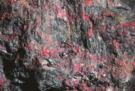
“Home to the second largest mercury mine in the world”
Celebrating Earth Heritage
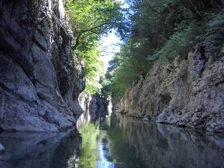
The Idrija UNESCO Global Geopark is situated in the western part of Slovenia, approximately 60 km from Ljubljana. It is located at the junction of the Dinarides and Alps mountain ranges. This has resulted in exceptional geoheritage of deep gorges where a variety of rocks have been discovered in remarkable stratigraphic cross sections, tectonic phenomena and mineral and fossil deposits. In addition, water contributes to the variety of the terrain with numerous features and water courses.
The extensive tectonic movements shaping the terrain within the Idrija UNESCO Global Geopark, began in the Anisian, lasting throughout the Triassic. The area’s mercury ore deposits, supporting 500 years of mining, and now a UNESCO world heritage site, was formed during this period. Owing to complex tectonic events, the carbonate sedimentation was interrupted in the Upper Cretaceous, forming flysch rocks in the foreland basin. Due to extensive tectonics, the majority of contacts between the sequences of different Carboniferous to Paleocene-Eocene rock strata are tectonic. Most of the rocks are carbonates and clastic sedimentary rocks of Permian, Triassic and Cretaceous age. Outcrops due to Ladinian volcanism have been found in the western part of the UNESCO Global Geopark. Due to the pushing of the Adriatic microplate under the European plate in the Miocene, the terrain has a typical thrust structure.
Sustaining local Communities
The Idrija UNESCO Global Geopark lies within the Municipality of Idrija, with a population of 12,000 inhabitants.
Idrija UNESCO Global Geopark places great emphasis on raising awareness among the younger generations, on the importance of its heritages. The UNESCO Global Geopark connects and collaborates with different institutions and individuals concerned with the preservation of the area’s heritage (Idrija Mercury Mine, Idrija Mercury Heritage Management Centre, the Idrija Municipal Museum, the Municipality of Idrija, Slovenian National Commission for UNESCO, various associations and non-governmental organizations). Activities include education, particularly through the innovative integration of natural and cultural heritage in educational programs for local schools. For this purpose, a network of elementary schools has been created, with joint practical activities in the town and in rural areas. The UNESCO Global Geopark’s main objectives are the integration of heritage with educational activities of local schools, improving heritage awareness, popularising science content and promoting creative thinking.
BIBLIOGRAPHY
http://www.unesco.org/new/en/natural-sciences/environment/earth-sciences/unesco-global-geoparks/list-of-unesco-global-geoparks/