GEOGRAPHY CLIL LESSONS 1
December 2019
CLIL - Geography CLIL lessons
School: Liceul Tehnologic Octavian Goga Jibou, Romania
Geography Clil lesson.docx
Age of students/Grade: 11 years old /5th grade
Level of English: A1
Teacher(s): Nagy Melinda
Subject(s): English / Geography
Topic: United Kingdom
Aims:
- To present the United Kingdom
- To present a country of the UK
- To draw a map
- To collect information about famous landmarks in the cities
Teaching points:
| Language | Content |
- Island
- Monument
- Stadium
- Landmark
- Bridge
- Wall
| - Countries of the United Kingdom
- Capital cities
- Important cities and landmarks in the UK
|
Resources: : hand-outs of the lesson, video projector, laptop, speakers, tablet
Description of the activities:
Activity 1: To present the United Kingdom
- T explains the use of “the” with geographical names and hands out the picture dictionary
- T asks Ss to look at the map. Plays the recording.
- Ss listen to and read the texts and identify the cities 1-8
- T checks Ss’ answers
Activity 2: To present a country of the UK
- T asks Ss to work in group and assigns each group a country and to copy the table into their notebooks, complete it with the information in the texts
- T asks various Ss to present one of the countries of the UK to the class
Activity 3: Digital Poster creation
- Ss work in groups of 4 and create a poster for the country they were assigned
- Ss present their work
Supplementary materials:
Poster creation using: PosterMyWall
School: C.E.I.P. Santa María del Mar-Alisios
clil lesson, geography.pdf
Age of students/Grade: 10/12 years old 5th / 6 th grade
Level of English: A1
Teachers: Montserrat Fernández & Myriam Monzón
Subjects: English / Geography/Arts and Crafts
Topic: My country
KEY COMPETENCES
• Social and Civic Competence
• Cultural Awareness
• Communicative Competence - Ability of Expressing
• Learning to learn
OBJECTIVES
• Locating the partner countries on a European map.
• To pronounce countries’ names in English language.
• Identifying the flags of the partner countries.
• communicative functions (eg. to introduce my country, describe maps and flags)
• vocabulary: colors, natural elements (mountain, volcano, sea, island…) cardinals points
• communicative functions: Where are you from? Where do you live? What colour is the…flag? What/ Who’s your favourite…?
• structures There is, There’s, There are, simple present, do you…?
MATERIALS AND RESOURCES
Videoprojector, smart board, tablets, notebook and worksheets
Songs: “Cardinal directions song” and “Spain Geography”
from YouTube https://youtu.be/f2I81_BFb-s
https://youtu.be/GFWiXN9E3CQ
“About Teide, the third highest volcano in the world”
from YouTube https://youtu.be/7z3MvftjV5E
LEARNING PROCESS
Activity 1: draw and colour our flag and the flags of the partner countries.
Activity 2: colour our country and the partner countries on a European map.
Activity 3: sing and mime the actions of “Cardinal direction song” Activity
4: watch the video “About Teide, the third highest volcano in the world” and answer the questions using the class tablets.
School: Vilniaus Sausio 13-osios progimnazija, Lithuania
Geography CLIL LT_3.docx
Age of students/Grade: 11 years old /5th grade
Level of English: A1
Teacher(s): Šunina Žana
Subject(s): English / Geography
Topic: The United Kingdom
Aims:
- To present and practise topic-related vocabulary
- To listen and read for specific information
- To consolidate information in a text
- To draw a map and write a fact file
Teaching points:
| Language | Content |
- Capital city
- Official language
- Include
| - The UK, its capital city and the countries it consists of
- A map of the UK
- A map of Lithuania
|
Resources: Videoprojector, laptop, handouts of the text, speakers
Description of the activities:
Activity 1: To present and practise topic-related vocabulary
- T gives Ss time to look up the meanings of the words in the dictionaries. T explains the words and gives examples.
Activity 2: To listen and read for specific information
- Ss look at the map and elicit the country. T plays the recording. Ss listen to the text and read it to match the countries to the nationalities (ANNEX 1).
Activity 3: To consolidate information in a text
- T gives Ss time to complete the table (ANNEX 2).
- T asks various Ss around the class to present the UK to the rest of the class.
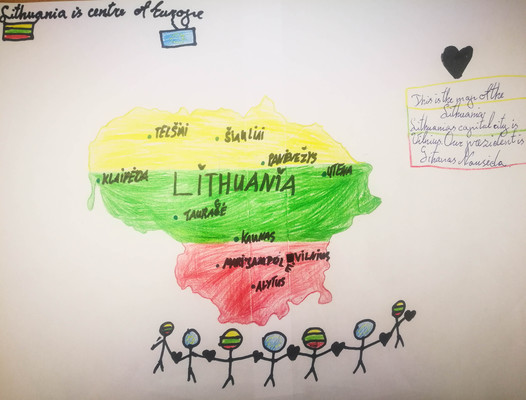
Activity 4: To draw a map and write a fact file
- T gives Ss time to draw a map of Lithuania including the capital city and other main cities and write a short fact file about it.
- T asks various Ss to present their maps to the class.
Supplementary materials (books, links, etc).
“On Screen 1” – textbook for the 5-6th grades, Express Publishing, page 22.
ANNEX 1
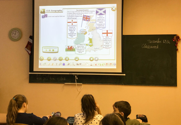
The United Kingdom
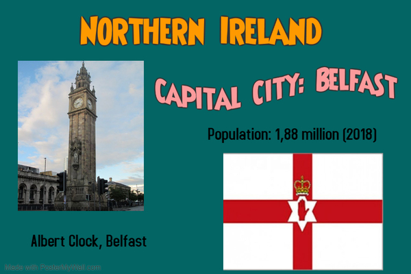
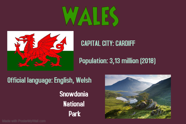
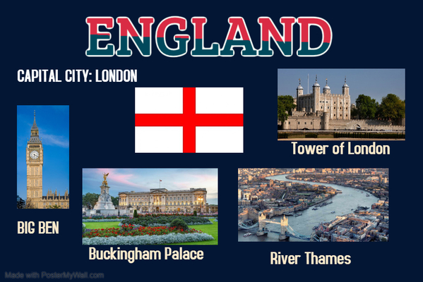
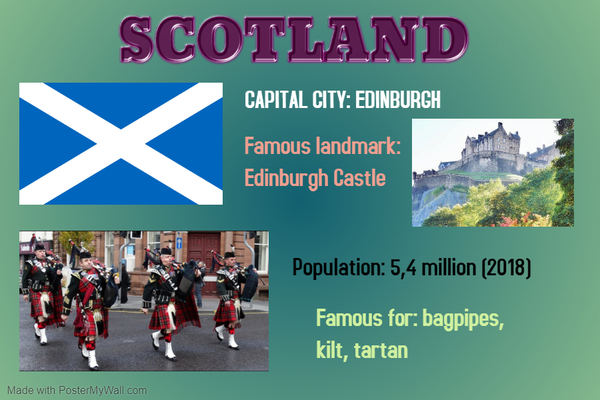
The UK includes: England, Scotland, Wales and Northern Ireland. London is the capital city of the UK and England. English is the official language.
This is England. Its capital city is London. Its official language is English.
This is Scotland. Its capital city is Edinburgh. Its official languages are English and Scottish Gaelic.
This is Wales. Its capital city is Cardiff. Its official languages are English and Welsh.
This is Northern Ireland. Its capital city is Belfast. Its official languages are English and Irish.
ANNEX 2
Complete the table. Then present the UK to the class.
| Country | Capital City | Official language(s) |
| England | | |
| Scotland | | |
| Wales | | |
| Northern Ireland | | |
CLIL - Geography CLIL lessons
School: Agrupamento de Escolas do Barreiro, Portugal
CLIL - Geography - Portugal.docx
GEOGRAPHY CLIL LESSONS 2
MARCH 2020
Liceul Tehnologic Octavian Goga Jibou, Romania
Geography Clil RO_2.docx
Age of students/Grade: 11 years old /5th grade
Level of English: A1/A2
Teacher(s): Nagy Melinda
Subject(s): English / Geography
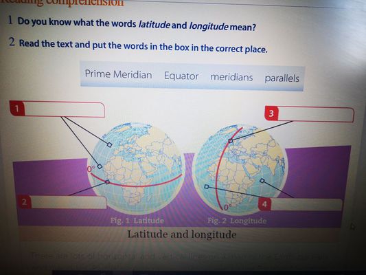
Topic: Latitude and longitude
Aims:
- To know the difference between latitude and longitude
- To present a museum
- To understand a written text
Teaching points:
| Language | Content |
- Measure
- Degrees
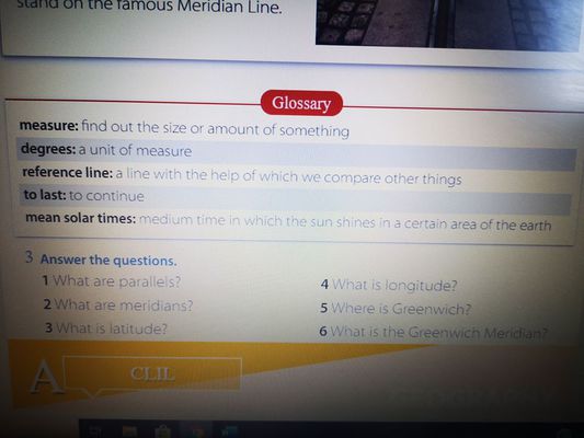
- reference line
- to last
- mean solar time
| - Latitude & Longitude
- Equator & Prime Meridian
- Meridians & Parallel
|
Resources: : internet connection, Zoom app, laptop/smartphone/tablet
Description of the activities:
Activity 1: To check Ss students knowledge of Latitude & Longitude
-Ss expain the difference between Latitude & Longitude
Activity 2: Reading & Comprehension
- 1. Ss Read the text and put the words in the box in the correct place.
- 2. Ss Answer the questions related to the text
Activity 3: Dialogue Practice/Writing Practice
- Mark is going on a trip to Greenwich and he wants to visit the National Maritime Museum. Ss fill in the blanks with the phrases below
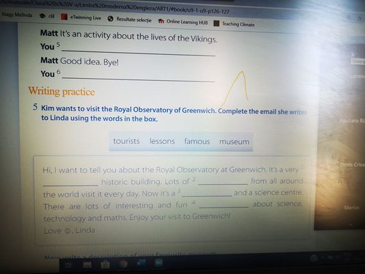
- Kim wants to visit the Royal Observatory of Greenwich. Ss complete the email she writes to Linda using the words in the box
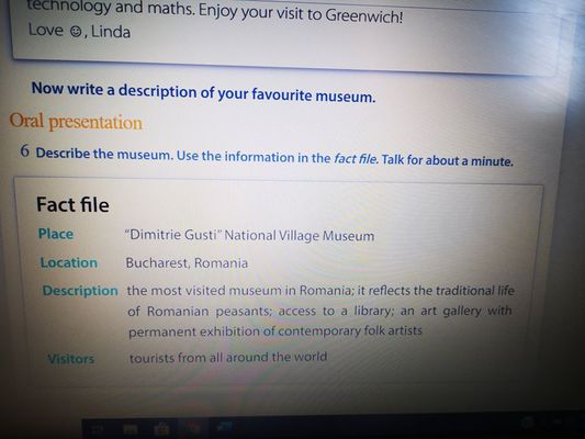
ORAL PRESENTATION: Ss present information about their favourite museum
https://manuale.edu.ro/manuale/Clasa%20a%20V-a/Limba%20moderna%20engleza/ART1/#book/u9-1-u9-p126-127
School: Vilniaus Sausio 13-osios progimnazija, Lithuania
Geography CLIL lesson LT (2).docx
Age of students/Grade: 10-11 years old /4th-5th grade
Level of English: A1
Teacher(s): Žana Šunina
Subject(s): English / Geography
Topic: Bring Your Umbrella
Aims:
Teaching points:
| Language | Content |
- Region
- Wellington boots
- North
- South
- East
- West
- Dry
- Mild
- Cool
- Flood
- Hurricane
- Predict
- Average
| - The weather in tke UK.
- Different types of weather.
- Temperatures.
|
Resources: computers/laptops/tablets/mobile phones, Zoom app, internet connection.
Description of the activities:
Activity 1: To introduce the topic and new vocabulary
- T directs Ss to the new words. T explains/elicits the meanings of any unknown words.
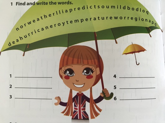
- T asks Ss to find the words in a row of letters and write them down ‘’norweatherlliapredictsoumildbodloqdeahurricaneroytemperatureworregionapq’’. (the words hidden are: weather, predict, mild, hurricane, temperature, region).
- Ss present the words they found to the class.
Activity 2: To read for specific information
Activity 3: To identify true or false statements based on information from the text.
- T asks Ss to identify true and false statements according to the text (ANNEX 2).
- T checks Ss’ answers.
Activity 4: To consolidate prior knowledge with new information in the text.
- T asks questions ‘’What did you know about the weather in the UK?’’, ‘’What new things did you learn from the text?’’, ‘’What would you like to know about the weather in the UK?’’.
- T asks various Ss to share their answers with the class.
Activity 5: To develop research and IT skills.
- T explains to students that different parts of the UK have got different types of weather. T points out that Ss should use the Internet to find the answers (ANNEX 3).
- Ss do this task as homework.
- Ss present their homework the next lesson.
Supplementary materials:
“Welcome to the UK” – CLIL readers, Express Publishing, pages 16-17, 36-37.
ANNEX 1
Read the text and complete sentences.
Bring You Umbrella
‘’Rain, rain, go away. Come again another day.’’ This famous rhyme is a good description of the weather in the UK. Rain in the UK is not unusual. In fact, it rains there about one in three days on average. But you don’t always need wellington boots and umbrellas. Some parts of the country are actually quite dry! For example, London receives less rain each year than Rome and New York City.
It’s difficult to predict the weather in the UK. It changes from day to day and from region to region. There are slightly different climates depending on where you are. For example, the north-east of the UK has got cool summers and cold winters. However, the south-east has got warm summers and mild winters.
But how ‘’warm’’ are the summers? Well, it’s very unusual for the UK to have high temperatures. England is generally the warmest of the four countries and Scotland is the coolest. The average temperature for July in Glasgow, Scotland is 19 degrees Celsius compared to 22 degrees Celsius in London.
Did you know?
- The UK doesn’t have much extreme weather, although there are sometimes floods and hurricanes.
- Ben Nevis, in Scotland, is the coldest place in the UK!
1. It rains about one in three days on .......... in the UK.
2. You need ........... and an umbrella when it rains.
3. Some parts of the UK are quite .......... .
4. It’s difficult to .......... the weather in the UK.
5. It’s unusual for the UK to have high .......... .
6. There are sometimes .......... in the UK.
Answers: 1-average; 2-wellington boots; 3-dry; 4-predict; 5-temperatures; 6-hurricanes.
ANNEX 2.
Match true or false statements.
1. Rain is very unusual in the UK.
2. London receives less rain tha Rome each year.
3. Weather changes from day to day in the UK.
4. All over the UK the climate is the same.
5. The north-east of the UK has got warm summers.
6. The south-east of the UK has got mild winters.
7. England is the coolest of the four countries.
8. Ben Nevis is the coldest place in the UK.
Answers: 1-false, 2-true, 3-true, 4-false, 5-false, 6-true, 7-false, 8-true.
ANNEX 3.
Read and match the correct answer. Use the Internet to help you.
1. The west and north-west is wetter/drier than the east.
2. The north and west is less windy/windier than the south and east.
3. The south coast of England is the sunniest/wettest part of the country.
4. Temperatures in the south/north of the UK are usually lower.
5. It is sunnier/wetter in the mountains in the west.
GEOGRAPHY CLIL LESSONS 3
OCTOBER 2020
Liceul Tehnologic Octavian Goga Jibou, Romania
Geography CLIL_ RO 3.docx
Age of students/Grade: 11 years old /5th grade
Level of English: A1
Teacher(s): Nagy Melinda
Subject(s): English / Geography
Topic: Weather Around the World
Aims:
-to enrich and revise vocabulary related to weather, clothes and holiday items
-to learn about different climates around the world
Teaching points:
| Language | Content |
| Vocabulary related to: -weather -clothes -holiday items | Different climate around the world |
Resources: : hand-outs of the lesson, video projector, laptop, speakers, tablet
Description of the activities:
Activity 1: - revising and enriching vocabulary related to weather
https://www.youtube.com/watch?v=GKGKdV5NunI
Activity 2: practising vocabulary related to weather, matching the words with the pictures
https://learnenglishkids.britishcouncil.org/word-games/weather-1
Activity 3: Poster creation
Matching the labels of countries with the approapiate suitcases
Suitcases[1][1].doc
Suitcase_labels[1].doc
School: Vilniaus Sausio 13-osios progimnazija, Lithuania
Geography CLIL LT (3).docx
Age of students/Grade: 12-13 years old /6th grade
Level of English: A2
Teacher(s): Žana Šunina
Subject(s): English / Geography
Topic: Clouds
Aims:
Teaching points:
| Language | Content |
- Be made of
- Drop
- Ice
- Thin
- Float
- Reflect
- Thick
- Flat layer
- Light rain
- Sprinkle of snow
- Blanket
- Hang low
- Ground
- Fog
- Fluffy
- Cotton wool
- Fair weather
| - Types of clouds.
- Differences between clouds.
|
Resources: videoprojector, laptop, handouts of the text, dictionaries
Description of the activities:
Activity 1: To introduce the topic and present new vocabulary
- T reads the title of the text ‘’Clouds’’ and invites Ss to tell the class what they know about clouds.
- Ss look at the pictures of the clouds. T explains that there are four types of clouds and elicits their names (Stratus, Cumulus, Cirrus, Nimbus).
- T reads the sentences (ANNEX 1) aloud and explains the meaning of any unknown words.
- Ss match the sentences to the types of clouds shown in the pictures.
- T elicits answers from Ss around the class.
Activity 2: To read for comprehension.
Activity 3: To identify antonymous words.
- T reads out the words from the list (thick, ordinary, uneven, heavy, far, small, bright) and gives time to match them to the highlighted words in the text. Ss can use dictionaries if necessary.
- T checks Ss’ answers (thick-thin; special-ordinary; flat-uneven; light-heavy; near-far; big-small; dark-bright).
Activity 4: To consolidate information in a text through comparisons.
- T asks Ss to read the text again and compare the different types of clouds.
- T elicits sentences from Ss around the class.
Activity 5: To consolidate new vocabulary.
- Ss complete the mind map with words connected to the clouds.
- T gives Ss handouts with new words/phrases and their meanings/definitions. Ss have to match the words to their definitions (ANNEX 4). Before the lesson T cuts the sheet of paper (ANNEX 4) so that the definitions of the words are on separate slips of paper. Ss do the task in pairs or in groups of three.
- T gives time to look up the meanings of the words in dictionaries.
- T checks Ss’ answers.
Activity 6: To consolidate information in a text.
- Ss tell the class four things they learnt from the text.
Supplementary materials:
“The Weather” – CLIL readers, Express Publishing, pages 6-7, 26.
‘’On Screen 2’’ Student’s book, Express Publishing, page 58.
ANNEX 1
Match the sentences to the correct type of cloud.
1. They are big and fluffy.
2. They form in flat layers.
3. They cover the sky.
4. They are wispy and made of ice crystals.
5. They look like a grey blanket that hangs in the sky.
Answers: 1. Cumulus; 2. Stratus; 3. Nimbus; 4. Cirrus; 5. Stratus.
ANNEX 2
Read the text.
Clouds
Clouds are made of drops of water or ice. These drops are small and thin so they can float in the air. Clouds are white because they reflect the light of the sun. When they get thick or high above light, they look grey. There are four types of clouds, each one different and special.
STRATUS
These clouds form in flat layers. They often bring light rain or sprinkles of snow. They look like a grey blanket that hangs low in the sky. When they are near the ground, we call them fog.
CUMULUS
These clouds are big and fluffy and look like balls of cotton wool one on top of the other. People call them ‘’fair weather clouds’’ and we see them in the middle of the sky when the weather is good. Sometimes, they are white, other times they are grey.
CIRRUS
These clouds are thin and are high up in the sky. They are made of ice crystals. If you see them in the sky, yhen it will be a nice day.
NIMBUS
These clouds cover the whole sky and are dark. They are low in the sky and bring heavy rain or snow.
ANNEX 3
Answer the questions.
1. What do cumulus clouds look like?
2. Which clouds can be grey?
3. When do we call stratus clouds fog?
4. Which clouds can bring rain or snow?
5. Which clouds suggest the weather will be nice?
ANNEX 4
Match the words/phrases to their definitions.
| be made of | consist of |
| drop | a small amount of liquid |
| ice | frozen water |
| float | to hang in the air |
| reflect | to send light back from its surface |
| thick | not thin |
| flat layer | a level of sth that is smooth |
| light rain | drizzle |
| sprinkle of snow | a light snowfall |
| blanket | covering |
| hang low | to be suspended not far off the ground |
| ground | the earth |
| fog | thick clouds near the ground that make it difficult to see |
| fluffy | soft and light |
| cotton wool | a soft mass of cotton |
| fair weather | good weather, sunny and not rainy |
GEOGRAPHY CLIL LESSONS no.4
January 2021
School: Liceul Tehnologic Octavian Goga Jibou, Romania
Geography CLIL lesson no4 RO.docx
Age of students/Grade: 11 years old /5th grade
Level of English: A1
Teacher(s): Nagy Melinda
Subject(s): English / Geography
Topic: The Continents
Aims:
-to enrich and revise vocabulary related to continents
-be able to locate and recognize the seven continents on a map of the world
Teaching points:
| Language | Content |
| rainforest waterfall island | The 7 continents: Asia, Africa, North and South America, Antarctica, Europe, Australia |
Materials: internet connection, Google Meet, laptop/tablet/computer/smartphone, online worksheets
Description of the activities:
Activity – introduction of vocabulary
-while watching the video on YouTube about the 7 continents, students need to write their names
https://www.youtube.com/watch?v=K6DSMZ8b3LE&feature=emb_logo
Activity 2: - reading for specific information
-teachers shares screen with the lyrics of the continent song, students need to complete the worksheet, fill in the gaps with the given words
Worksheet: https://www.liveworksheets.com/mn621486fi
Activity 3 – Quizzes
The activities are followed by the 2 online quizzes related to continents and geographical features
Online Quiz 1: https://www.liveworksheets.com/at1400542cu
Online Quiz 2: https://www.liveworksheets.com/xv633461vq
School: Vilniaus Sausio 13-osios progimnazija, Lithuania
Geography CLIL LT 4.docx
Age of students/Grade: 13-14 years old /7th grade
Level of English: A2
Teacher(s): Žana Šunina
Subject(s): English / Geography
Topic: Mountains
Aims:
Teaching points:
| Language | Content |
- The Earth’s crust
- Fold upwards
- Mountain range
- Extreme weather
- Altitude
- Rocky ground
- Survive
- Adapt
- Harsh environment
- Mountain path
- Tons of rubbish
- Continent
- Length
- Widlife
| - Formation of mountains
- The Himalayas
- Mountain ranges in your continent
|
Resources: computers/laptops/tablets/mobile phones, Zoom app, internet connection.
Description of the activities:
Activity 1: To introduce the topic
- T explains how the mountains are formed (ANNEX 1).
- T asks Ss to think of three questions Ss want to find out about the Himalayas.
Activity 2: To read for specific information
- Ss read the text ‘’The Himalayas’’ (ANNEX 2).
- Ss find the answers to the questions they have thought about.
- Ss find the information that refers to the numbers in the text: 14 – 200 – 27,000 – 2,400 – 20 – 8,000 (ANNEX 3).
- Ss read the text again and find the: continent the Himalayas are in; five countries the Himalayas cross; names of four animals; capital city of Nepal (ANNEX 4).
Activity 3: To consolidate new vocabulary
- T gives Ss time to look up the meaning of the highlighted words in their English-English dictionaries.
- T asks Ss to explain the meaning of the highlighted words (ANNEX 5).
Activity 4: To consolidate information in the text.
- T asks various Ss to present the information they remember from the text.
Activity 5: To develop writing and communication skills.
- T asks Ss to find out information about a mountain range in your continent. T points out that Ss should write a text about where the mountain range is, its length/height, people/wildlife.
- Ss do this task as homework.
- Ss present their homework the next lesson.
Supplementary materials:
“Upstream Elementary A2” – Student’s book, Express Publishing, page 41.
ANNEX 1
How Are the Mountains Formed?
The ground we stand on is called the Earth’s crust. When there is a strong push under that crust, continents hit each other, fold upwards and form mountains.
ANNEX 2
The Himalayas
The Himalayas (or ’’Land of Snow’’) in Asia is in the highest mountain range in the world! It is 2,400 km long and 200 km wide. It crosses Northeastern Pakistan, Northern India, Southern China (Tibet), Nepal and Bhutan. Ten of the world’s 14 highest mountains, including Mount Everest, are part of the Himalayas and are all over 8,000 metres high.
Extreme weather conditions, high altitudes and rocky ground make life very difficult for people who live in the Himalayas. These people use simple hand tools and oxen to grow just enough food to live. Many animals and plants cannot survive there. Some, however, have adapted to the harsh environment. Among them are the mountain goat, with its thick warm coat and strong hooves, the red panda, the snow leopard and the yak.
Like other mountain areas, the Himalayas attract many tourists. In 1964, only 20 hikers visited Kathmandu, the capital of Nepal. In 2000, there were 27,000! This tourism provides income for locals, but it also causes many problems as tourists destroy mountain paths and leave tons of rubbish behind.
ANNEX 3
What do the following numbers refer to?
14 – 14 world’s highest mountains;
200 – 200 km width of the Himalayas;
27,000 – the number of hikers who visited Nepal in 2000;
2,400 – 2,400 km length of the Himalayas;
20 – the number of hikers who visited Nepal in 1964;
8,000 – 8,000 m minimum height of the Himalayas’ 10 highest mountains.
ANNEX 4
Read again and find the:
1. Continent the Himalayas are in (Asia).
2. Five countries the Himalayas cross (Northeastern Pakistan, Northern India, Southern China (Tibet), Nepal and Bhutan).
3. Names of four animals (the mountain goat, the red panda, the snow leopard, the yak).
4. Capital city of Nepal (Kathmandu).
ANNEX 5
Explain the words
Mountain range – a long line of mountains;
cross – pass through/over;
extreme (weather) – very cold/hot/wet etc;
rocky ground – area with lots of large stones;
survive – to manage to live;
adapt – to change and become better suited to something;
harsh (environment) – very difficult;
attract – to make people want to go to the place;
path – walkway from one place to another;
tons of rubbish – lots of junk.
GEOGRAPHY CLIL LESSONS 5
APRIL 2021
School: Vilniaus Sausio 13-osios progimnazija, Lithuania
Geography_5_Lithuania.docx
Age of students/Grade: 13-14 years old /7th grade
Level of English: A2/B1
Teacher(s): Žana Šunina
Subject(s): English / Geography
Topic: How Does a Waterfall Form?
Aims:
Teaching points:
| Language | Content |
- Hard rock
- Soft rock
- Erosion
- Plunge pool
- Surface
- Overhang
- Collapse
- Adapt
- Retreat
- Steep-sided valley
- Gorge
- Continent
- Length
- Widlife
| - Formation of waterfalls
- Famous waterfalls
|
Resources: computers/laptops/tablets/mobile phones, Zoom app, internet connection.
Description of the activities:
Activity 1: To introduce the topic
- T asks Ss to think of the facts they already know about waterfalls and what Ss want to find out waterfalls.
- Ss watch the video about volcanoes:
https://www.youtube.com/watch?v=ilJzge07mcs
Activity 2: To read for specific information
Activity 3: To practise research and speaking skills
- T gives Ss time to find answers to the question (ANNEX 2) on the internet.
- Ss discuss the answers in pairs in breakout rooms.
- T asks various pairs of Ss to present the information they have found.
Supplementary materials:
“On Screen 3” – Workbook, Express Publishing, page 21.
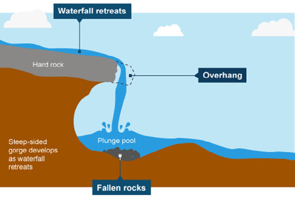
ANNEX 1
How Does a Waterfall Form?
A waterfall occurs when a river, travelling on its way towards the sea, flows over a boundary between a hard rock and soft rock. Over time, the force of the water wears away the soft rock in a process called erosion.
As the water crashes over the fall into the river below, it creates a plunge pool – an area of deeper water right underneath the waterfall. The water hitting the surface of the river is also constantly splashing - called splash back – slowly eats away at the soft rock behind the waterfall, carving out a cave behind the falling water and leaving the hard rock above sticking out. This shelf of hard rock is referred to as an overhang. Eventually, there is not enough soft rock to support the hard rock above and the overhang collapses into the plunge pool below.
This process of erosion and collapse happens again and again over the centuries. This causes the waterfall to retreat up the river, leaving behind a steep-sided valley called a gorge.
ANNEX 2
Questions for Pair Work
1. What is a waterfall?
2. How does a waterfall form?
3. How are waterfalls classified?
4. What are types of waterfalls?
5. What are the most famous waterfalls in the world? Present information about three famous waterfalls (country, height, interesting facts).
School: Liceul Tehnologic Octavian Goga Jibou
Geography CLIL no.5 RO.docx
Age of students/Grade: 11 years old /5th grade
Level of English: A1/A2
Teacher(s): Nagy Melinda
Subject(s): English / Geography
Topic: The Solar System
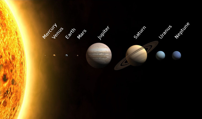
Aims:
-to practise ordinal numbers
-to learn about the solar system
| Vocabulary | Teaching points |
| Mercury, Venus, Earth, Mars, Jupiter, Saturn, Uranus, Neptune | Ordinal Numbers The Planets |
Resources: internet connection, laptop/tablet/smarphone, Google Meet, online worksheets
Description of the activities
Activity 1: Introduction
T asks Ss whether they know the name of the 8 planets. Ss write the names of the planets in their notebooks. T checks answers with the whole class. Then shares a link in the chat, where Ss need to find all the planets in the word grid.
https://www.liveworksheets.com/nz1262867mr
Activity 2: Watching and comprehension
T shares the YouTube video on the screen and asks Ss to write 1-2 characteristics of each planet as they watch the video.
https://www.youtube.com/watch?v=ZHAqT4hXnMw
Activity 3: Reading and Comprehension
T sends the link of the online worksheet in the chat. Ss read the text and label the planets.
https://www.liveworksheets.com/da1534097tn
Activity 4: Watching and comprehension/Evaluation
T sends the link of the online worksheet in chat. Ss watch the video and answer the questions.
https://www.liveworksheets.com/jq1430093mm