Kingdom of Württemberg and industrialization
Foundation of the Kingdom of Württemberg
Capital: Stuttgart
This lead to a tremendous economic, political and religious upswing
Beginning of the industrialization, which doubled the Population between 1834 and 1871
Stuttgart became Württembergs’ mixed confessional metropolis
1846: inauguration of the first Württemberg railway --> route from Cannstatt to Untertürkheim and later also from the Rosenstein tunnel to Stuttgart. The elder main station was located at Schlossplatz.
1886: Gottfried Daimler and Wilhelm Maybach made the basis for one of the largest automobile companies in the world; Robert Bosch and Carl Benz also contributed to the economic boom in Stuttgart
After 1860s, manufacturing companies started to relocate their production facilities to the eastern and northern hinterland (e.g. Feuerbach, Zuffenhausen etc.) because of the shortage of space
In 1875: about 100,000 inhabitants; in 1905: 250,000 inhabitant
Königsstraße
The Königsstraße is the most famous street in Stuttgart. She invites you to go shopping and strolling. During the Football World Cup 2006, it was populated by a thousand fans from all over the world.
The upper Königstraße
However, before Königstrasse became a street, the old city wall of the Stutengarten settlement was located on this site. In the course of time, Stuttgart received a city wall. Three city gates led into the city, one of which was located at today's corner of Rotebühl / Königsstraße. The course of the former fortification can still be seen today on the upper Königstraße and the Eberhardstraße. Also the slope that was created by the pile up of the ramparts could still be seen on the streets leading to the Königstraße, for example the Schulstraße or the Hirschstraße.
(green map: Stuttgart before the city wall augmented it´s size, orange map: Stuttgarts city wall)
Lower Königsstraße
Medieval relics such as the fortifications disappeared from Stuttgart in 1808, after Württemberg was elevated to kingdom because they prevented the city from expanding. With the infusion of the great ditch, the Königsstraße was extended beyond the Schlossplatz and thus became the main street of Stuttgart.
King Frederick 1st wanted Stuttgart's increasing importance to be visible through the cityscape and supported the development of the lower Königstraße with representative private houses in the classic architectural style.Die Straßenbahn konnte ab 1922 die gesamte länge der Königstraße befahren. But until 1966, pedestrians, motorists and the tram had to get along on the road together. However, this problem could be solved between 1960 and 1970 by laying the tram under the ground and by building the Schlossplatz station.In 1970, the Federal Garden Show transformed Königstraße into a pedestrian zone by planting rows of trees. The architect's office Behnisch und Partner helped to accelerate the acceptance of the population regarding the pedestrian zone by building small squares with fountains and kiosks.
Summary of the development of Stuttgart from the First World War until after the Second World War
Stuttgart during the First World War
By an idea Stuttgart could escape the destruction of their city by bombs. At that time they switched off all the lights in Stuttgart and switched them on in Bad Canstatt. As a result, the pilots confused Stuttgart with Bad Canstatt and dropped the bombs there.
Stuttgart after the seizure of power by the National Socialists
Due to the lack of space in the city center, further incorporations took place after the Nazi seizure of power. In 1933, the city boundary shifted north to the junction of Feuerbach, Zazenhausen and Mühlhausen. The urban area was extended once more to the south with Sillenbuch, Heumaden, Uhlbach and Rohracker. In 1942 Birkach, Möhringen, Rohr, Vaihingen, Stammheim, Plieningen and Solitude formed the conclusion of the Stuttgart area.
Stuttgart after the second world war
The economic growth after the Second World War provided for rapidly expanding companies. The inflow of industry was fostered by the provision of suitable areas and a dense infrastructure network of the city, as surrounding communities soon offered cheaper offerings and became a competitor of the state capital.
In the 1960, residential areas were quickly built on the outskirts to remedy the housing shortage after the war. These were built, for example, in Rot, Giebel, Mönchfeld, Fasanenhof, Freiberg and Neugereut. From 1970, the city focused mainly on the renovation of old neighborhoods, the creation of recreational and cultural facilities and new pedestrian areas. The traffic that polluted and overcrowded the city center in 1950 was pulled out of the core city. Over time, the city transformed itself from a center of living to a center of services with cafes, department stores and shops.
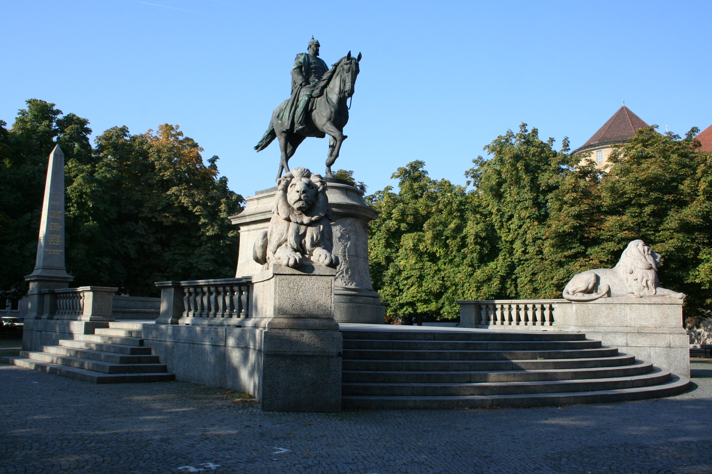
Karlsplatz
1393: garden of the duchess
1778:public space
1793:after the death of the duke they named it Karlsplatz
1795:they built a marble obelisc à became monumental place
1841: marble obelisc became a fountain
1898: fountain became Kaiser Wilhelm monument
1928: Karlsplatz became marketplace for thirty years
1970: built a holocaust memorial
Location
borderd by the old castle in the north and by the new castle in the east, by the old orphanage in the south and in the west by the Home office of Baden-Württemberg
surrounded by a lot of chestnut trees
Town Hall
History
Since 1456 there is a Town Hall at this place
1905 predecessor Town Hall à late gothic style à destroyed in 1944
1953-56 was rebuilt à side wings town hall tower of the old building were integrated into the new building
Location
is directly situated at the market place
Today
location of the city administration
in the Town Hall you can find three Paternoster lifts and a Glockenspiel

Market Hall
History
1911-1914 created by Martin Elsaesser
former vegetable market place
after second World War à destroyed
1953 rebuilt
Since 1974 under preservation order
Location
In the center of Stuttgart à Dorotheen street nr. 4
Architecture
Art nouveau building (era 19-20 century)
Surface of 6800 qm2
Today
Consumer market with an higher price segment with 37 sales stands

New palace
History
1746 was bulit by order of duke Karl Eugen of Württemberg
Aim: wanted to make Stuttgart the second versailles.
Was the location of the Kings
1944 destroyed
1958-64 rebuilt
Location
Builds with the old palace and the palace square the center of Stuttgart
Architecture
System with three wings
Today
State government uses the middle wing for receptions and events
In the side wing à ministry of finances and economy
In the cellar vaults roman lapidarium à collection of provincial roman stone monuments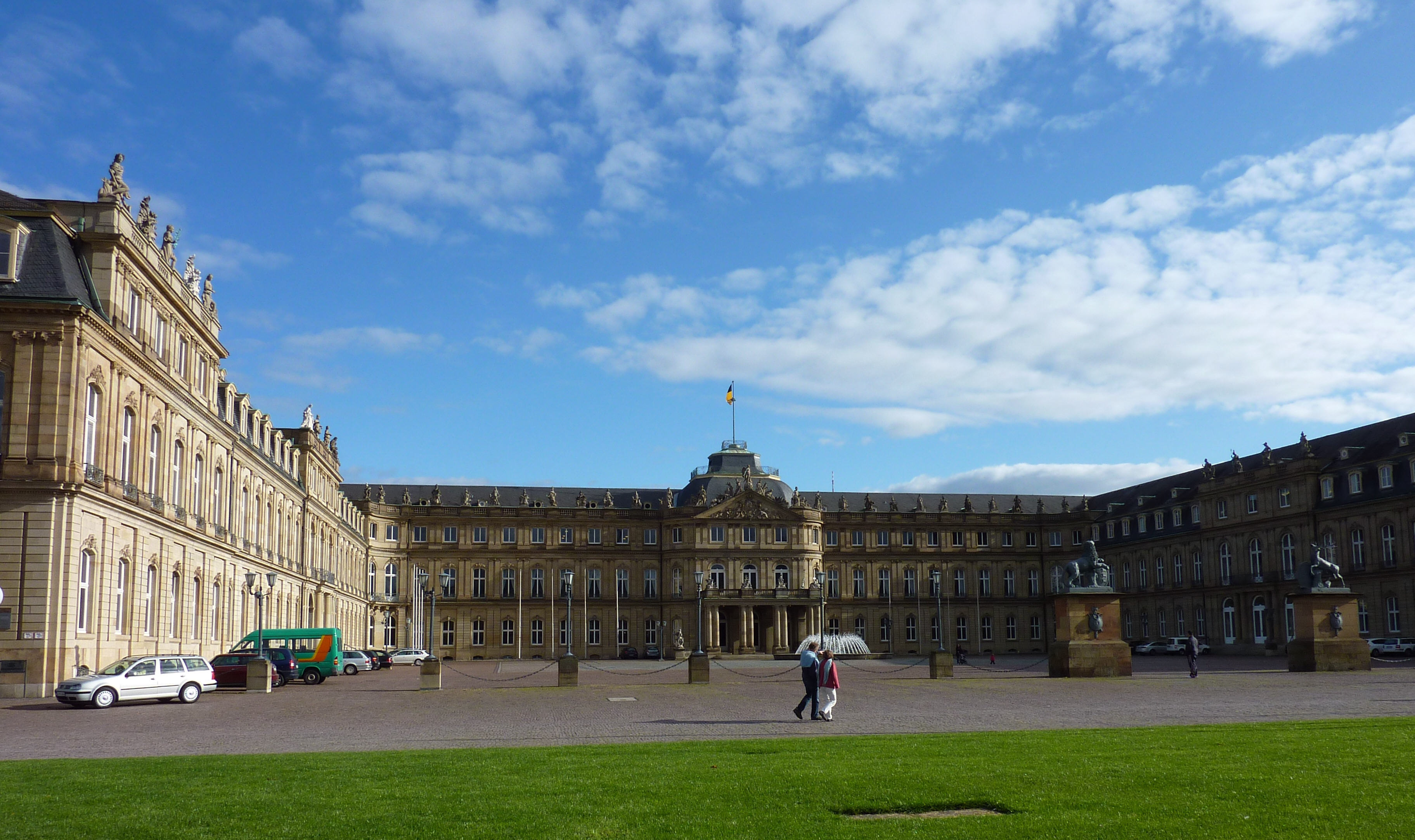
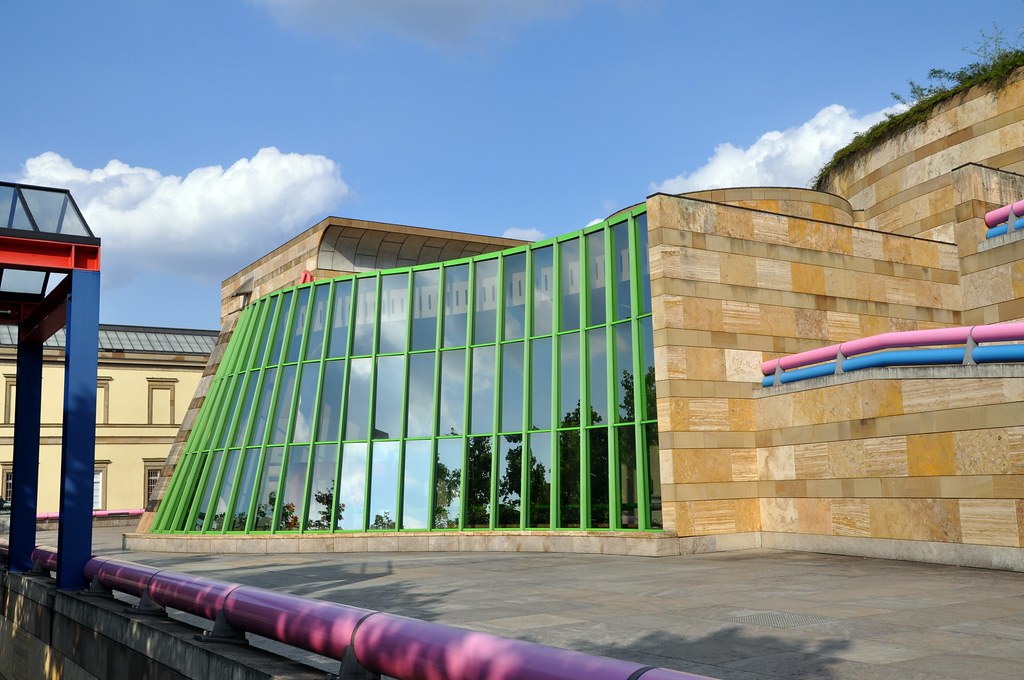
Staatsgalerie
History
1838-1842: was built
1843: opening
The original building was enhanced with 2 more wings
Former Staatsgalerie was a royal school of art
9th march 1984: inauguration of the new Staatsgalerie
Location
Near the opera at Konrad-Adenauer-Street
Architecture
Postmodern
Consists of 3 buildings
Today
More than 5000 paintings and statuary
Shows sculptures from the 14th century
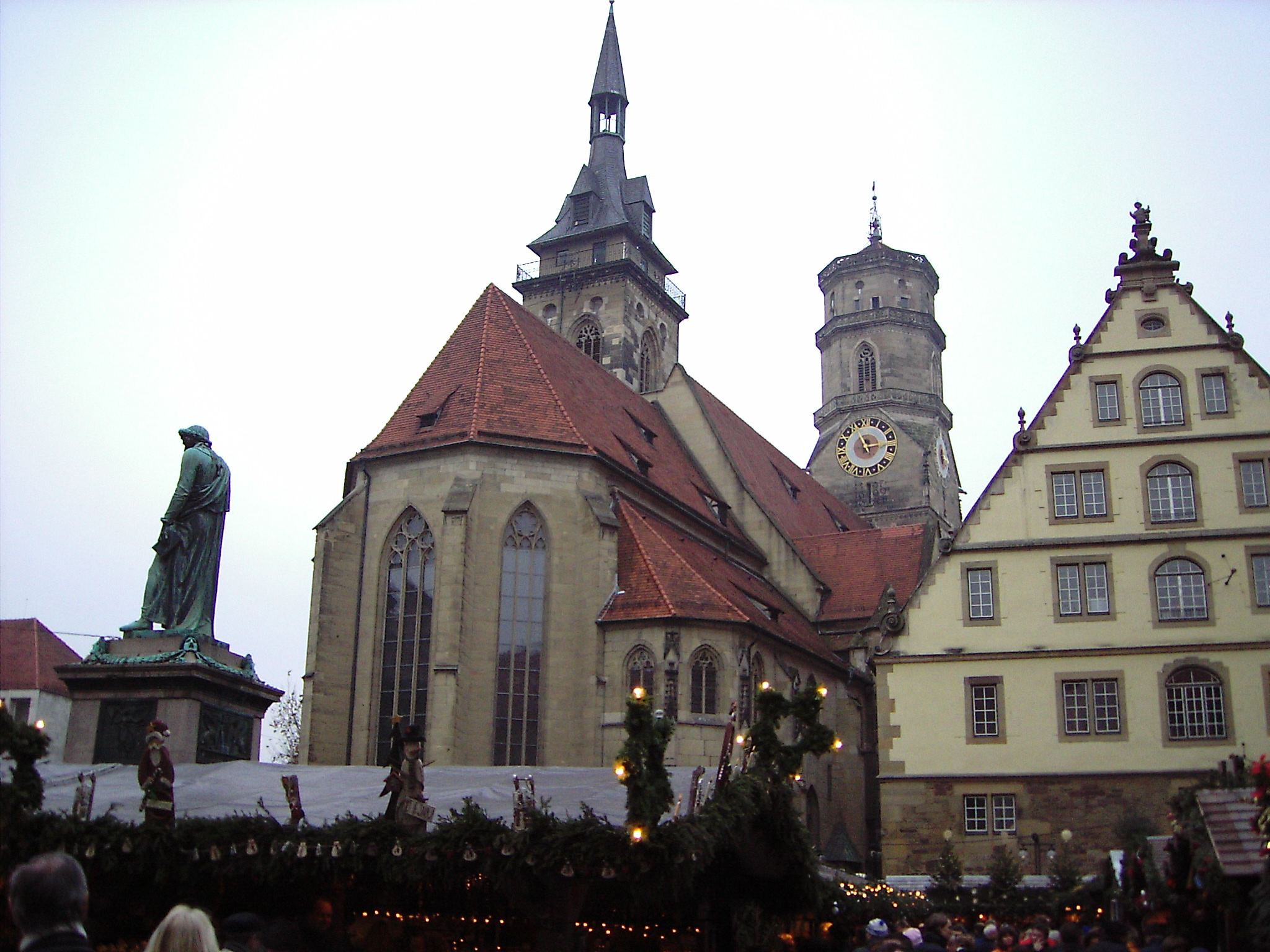
Abbey church
History
10th – 11th century: was built
First church in town
1944: Destroyed in second World War
1953: Reconstruction
1999-2003: Renovation
Location
Schillerplace(5)à concludes also Fruchtkasten, Princebuilding, old chancellery and old castle
Architecture
Romanesque period
10th – beginning of 14th century
Floor plan of todays church
Early Gothic
1320: town church became Abbey church
Chor was build in an an early gothic style
Late Gothic
15th century: a church ship was built in late gothic style
Today the church has also a gothic style
Today
Main church of the evangelicals national church
Church community has only 530 members
Old Castle
History
10th centuryà old castle was a former water castle
Was the place of the earls and dukes of Württemberg
Location
Belongs with the abbey church to the buildings of the Schillerplace
Architecture
Renaissance
Towers include the gorgeous arcade court which was built in the period of the south german renaissance
Today
State museum of Württemberg

State Theatre
History
Former royal theatre
1909-1912: was built
Since 1924: under monumental protection
After World War 2: only the opera with the classical pillars was obtained
1982-1984: interior spaces were led back to the originally state
Location
In the castle garden
Architecture
Consits of 3 separate categories à Opera(7), Ballett and theatrical performance
Today
Centre of the classic and modern music scene
Biggest in Europe

INFRASTRUCTURE OF STUTTGART TODAY
Stuttgart is an economically strong metropolitan region. The well-developed transport infrastructure is a good prerequisite for the fast transport of people and goods.
The motorways A8 and A81 cross at the gates of the state capital and offer good connections in all directions. In addition, Stuttgart is surrounded by a dense network of 3,500 kilometers of federal, provincial and county roads.
The backbone of the efficient public transport service is rail transport. The S-Bahn network alone has a length of more than 200 kilometers and travels over 80 stops. In addition, Stuttgart has the light rail (also called subway), several thousand bus stops throughout the region and special offers such as the Esslinger trolleybuses or the rack railway, which is also called "Zacke". The cooperation of the various transport providers in the Transport and Tariff Association Stuttgart (VVS) ensures an advantageous local traffic.
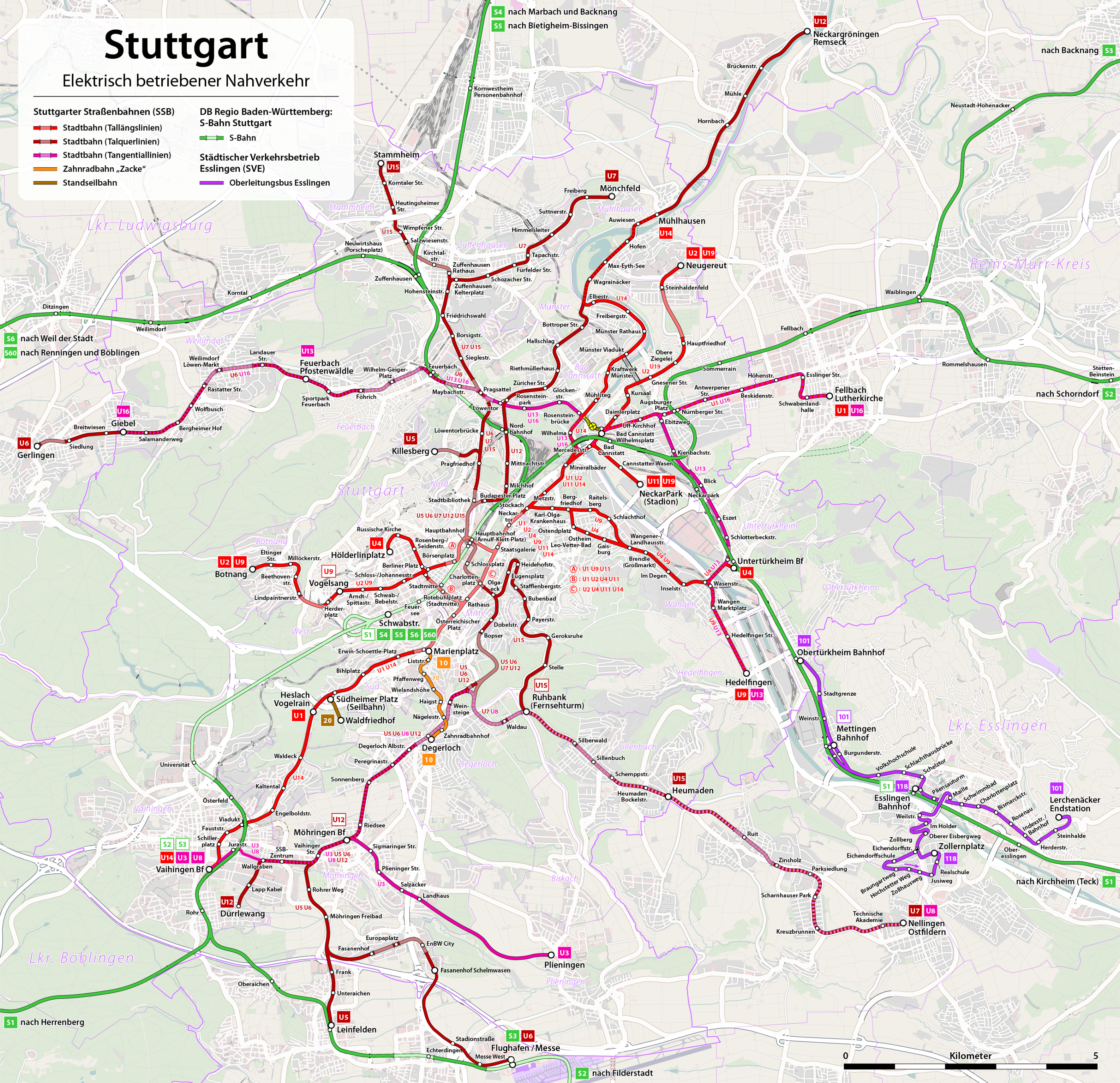
Stuttgart 21st
Soon, Stuttgart will be equipped with three new passenger stations and a new depot, as well as new fast-moving routes to rail transport in Baden-Württemberg. This is followed by a timetable with much more trains, more direct connections (without transfers) and shorter travel times.
The center of Stuttgarter is the new central station, which is converted into a transit station. The new main station is intelligently planned according to the state of the art and links the long-distance and regional traffic, ie the S- and Stadtbahn on short and barrier-free routes.

Emergence of the traffic infrastructure of Stuttgart
The first railway line
The construction of the first station in Stuttgart began in 1844, the first section between Cannstatt and Untertürkheim was opened on 22 October 1845 and completed the entire route to 1846.
In the 1950s, a four-lane stop with two 175-meter-long central platforms, designed to run in the direction of the city center and in the direction of Feuerbach / Bad Cannstatt, was designed for an S-Bahn saw under the main station. On 1 October 1978 drove the first rapid-transit railway.
Todays central station
The central station was built from 1914 to 1928 at today's Arnulf-Klett-Platz. In the air raids on Stuttgart in the Second World War, the central station was severely damaged several times. The reconstruction took several years. Since August 20, 1987, the Stuttgart Main Station is listed as a cultural monument of particular importance in the monument book.
The cog railway
The rack railway Stuttgart was opened on 23 August 1884 and connects the quarter Heslach in the urban district south, thus the city center in the valley, with the 1908 eingemeindeten municipality Degerloch. It is built meterpurig after the system Riggenbach and is operated by the Stuttgart street railways AG (SSB). In the vernacular, the railway is called Zacke, it is considered the Stuttgart landmark.
Stuttgart Airport
Stuttgart Airport is the international airport of the state capital of Baden-Württemberg, Stuttgart. It is located near Leinfelden-Echterdingen and Filderstadt. The first facilities on the present site were built in 1936, the current state of development has been largely realized in the years 1986 to 2004. The airport is ranked eighth of the largest airports in Germany.
Funicular Stuttgart
The funicular Stuttgart connects since 30 October 1929 the Südheimer Platz in the district Heslach without intermediate stop with the forest cemetery in the district Degerloch. It is operated by the Stuttgarter Straßenbahnen AG (SSB) and in Stuttgart itself usually referred to only as a "cable car". Since the late 1990s, it is also included as "Line 20" in the line number system of the Stadtbahn Stuttgart.
Shipping
On March 31, 1958, the port of Stuttgart was opened by Federal President Theodor Heuss. The four Neckar suburbs Wangen, Hedelfingen, Obertürkheim and Untertürkheim are the second largest inland port of the Neckar. After the expansion in 1968, it became the most important trimodal transport hub (water, rail, road) in the Stuttgart region.
Economy
Baden-Württenberg is one of the cities with the strongest income and economy. The GDP in in Stuttgart was approximately 93 billion EUR. That´s 30% of the Baden-Württenberg GDP. Stuttgart is seen as a „Beta City“ by Globalization and World Cities Research Network. What shows that Stuttgart is approved as on oft he stongest economic cities. The industry in Stuttgart is one of the advanced world wide. Companies like Mercedes, Porsche and Bosch where founded in Stuttgart. And till today these Companies are managing their business there. But not only big companies like the ones mentioned earlier are the reason for this economic strength. Also middle class companies are contribute to this sucess. Especially thanks to the car producing companies Stuttgart is in the machine engineering and electric engineering sector a leading factor. Furthermore just after frankfurt Stuttgart is the second leading exchange in Germany. Through a high employment rate and a high spending capacity of the Citziens of Stuttgart are helping to rise the economy. In Addition many Universities and Colleges like Forschungszentrum der deutschen Forschungsanstalt für Luft- und Raumfahrtechnik(DLR) or University Hohenheim are good examples for the advanced education system in Baden-Würtenberg. Not only that the Cars we built are really cool. Many people get a smile just by buying our products.