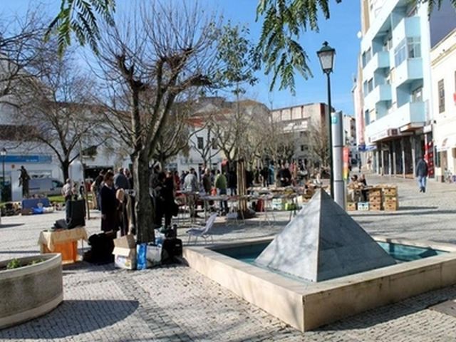
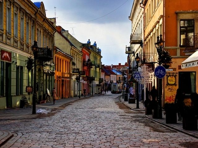
GAZIANTEP CITY DESCRIPTION
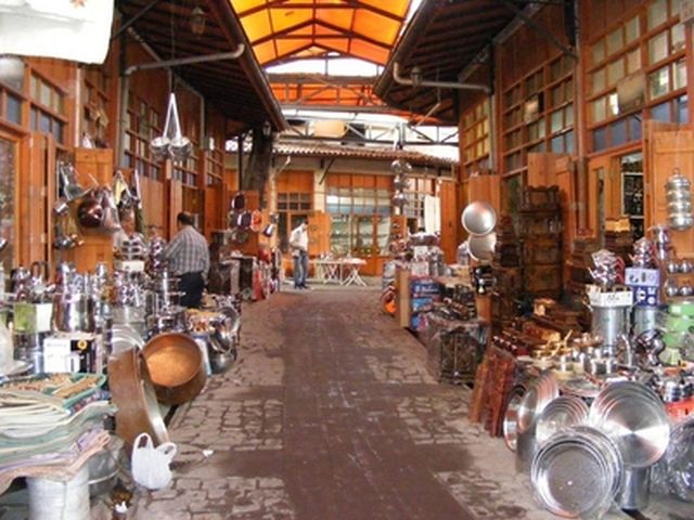
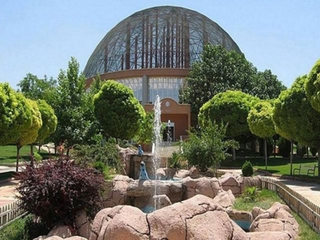
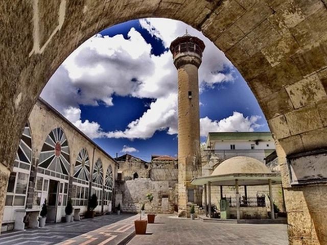
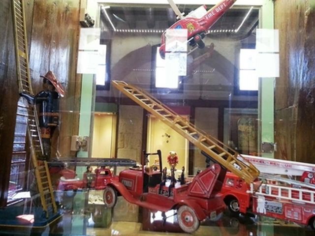
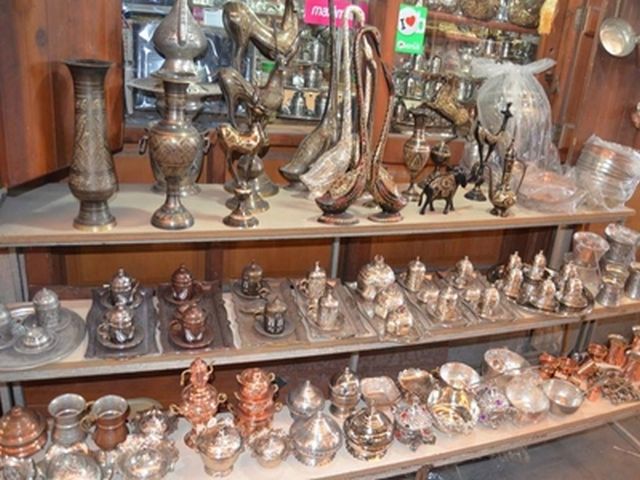
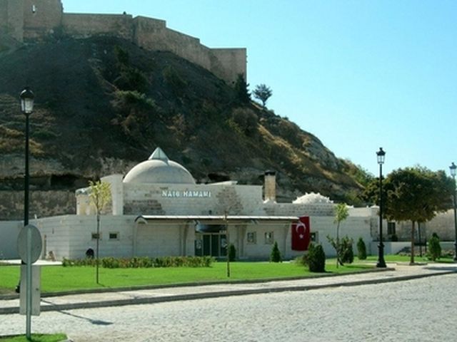
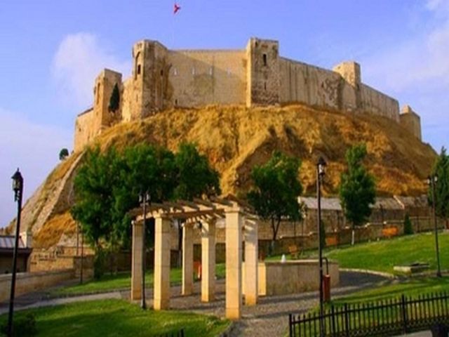
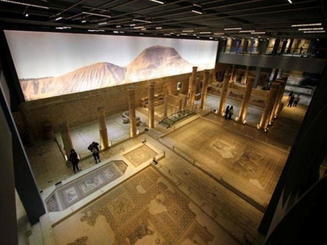
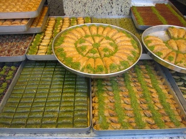
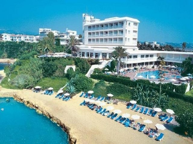
The province of Gaziantep is one of the oldest culture centers of Southeastern Anatolian Region. The history of the city extends to 4000 B.C years and most of the civilizations were founded on the surrounding lands. The city is located between Mesopotamia and Mediterranean and is at the intersection point of the roads connecting east to south and north to west and is also located on the historic Silk Road. The province of Gaziantep hosts findings, creations and structures of Paleolithic, Neolithic and Calceolithic Ages, Bronze Age, Hittite, Median, Asurian, Persian, Alexander the Great, Selefkos, Roman, Byzantine, Abbasi and Seljuk civilizations periods. Beside its cultural riches, Gaziantep is a tourism paradise with its natural beauties, geography, rich variety of food and shopping possibilities. The province of Gaziantep is located at the intersection point of both highway and railway transportation connecting south and Mediterranean to east and north and is at the entrance point of GAP. Gaziantep is a crucial point for highway transportation and is an important center of Silk Road. After World War I and Ottoman Empire's disintegration, it was invaded by the forces of the French Third Republic during the Turkish War of Independence. It was returned to Turkish control after the Treaty of Lausanne was signed, formally ending hostilities between Turkey and the Allies of World War I. Originally known as Antep, the title gazi (meaning veteran in Turkish) was added to the province's and the provincial capital's name in 1921, due to its population's extraordinary courage during the Turkish War of Independence. Gaziantep is famous for its regional specialties: the copper-ware products and "yemeni" slippers, specific to the region, are two examples. The city is an economical center of South Eastern and Eastern Turkey. The number of large industry businesses established in Gaziantep comprise four percent of the Turkish industry in general, and small industries comprise six percent. Also Gaziantep has the largest organized industrial area in Turkey and holds first position export and import goods. Gaziantep is one of the leading producers of machined carpets in the world. It exported approximately $700 million USD of machine-made carpets in 2006. There are over 100 carpet facilities in the Gaziantep Organized Industrial Zone. Gaziantep also produced 60,000 MT of pistachios in 2007. Turkey is third in pistachio production in the world, after Iran and USA. Gaziantep is well-known for its culinary specialties, which show Kurdish, Arabic and Assyrian in addition to Turkish, influences. The festive food yuvalama (rice and meat rolled into pea-sized balls), the delicious lahmacun (also known as Turkish pizza) , kebabs and baklava are some examples. Gaziantep also has a developing tourist industry. Development around the base of the castle upgrades the beauty and accessibility to the castle and to the surrounding copper workshops. New restaurants and tourist friendly businesses are moving into the area. In comparison with some other regions of Turkey, tourists are still a novelty in Gaziantep and the locals make them very welcome. Many of the students studying English language are willing to be guides for tourists. Since 1987, excavations of the ancient city of Zeugma have been carried out by the Gaziantep Museum Directorate and various teams. The excavations which continued for years with the support of the Gaziantep Governorship, came under the international spotlight due to the artefacts discovered in 2000. Two side by side villas were uncovered, which are known as the Poseidon and Euphrates villas, and these contained hundreds of square meters of floor mosaics, wall frescoes, a statue of Mars and many other smaller artefacts. Zeugma Museum is the biggest mosaic museum in the world. Gaziantep Zoo is the largest zoo in Turkey. Especially interesting are the bird pavilion and the aquarium. Gaziantep Zoo offers a large variety of animals, attractive picnic grounds, and a cafeteria. The facility is established on 1.000.000 m2 field. There are 264 species and 6.814 animals. Aquarium is fascinating. Zincirli Bedesten is the Ottoman era covered bazaar of Gaziantep and was built in 1781 by Hüseyin Pasha of Darende. This bazaar was used as a wholesale market hall for meat, fruit and vegetables. The city is home to many Turkish baths (Hamams), most of which date from the Ottoman and Dulkadir beylik period, namely the Hüseyin Pasha Baths, İki kapılı Baths, Tabak Baths, Şeyh Fethullah Baths and Şehitler Baths. Old houses of Gaziantep, the traditional houses of Gaziantep are located in the old city: Eyüboğlu, Türktepe, Tepebaşı, Bostancı, Kozluca, Şehreküstü and Kale. They are made of locally found keymik rock and have an inner courtyard called the 'Hayat' which is the focal point of the house. Rumkale was a powerful fortress on the river Euphrates, 50 km west of Şanlıurfa. Its strategic location was already known to the Assyrians, although the present structure is largely Hellenistic and Roman in origin. The site was occupied by various Byzantine and Armenian warlords during the Middle Ages. During the 12th c, it also became the seat of an Armenian bishop. In 1179, a synod took place in Rumkale. The fortress, now situated across a peninsula created by the reservoir of Birecik Dam. 100. Yıl Atatürk Kültür Parkı (100th Anniversary Atatürk Culture Park) is the largest park in Gaziantep located in the centre of the city along the Alleben river which has border for 5 km. The Gaziantep Toy Museum, which showcases nearly 600 toys produced between 1700 and 1990, arouses interest among children while taking adults on a journey through time.
Nazli Bilge Giçi, pupil, Vali Mehmet Lutfullah Bilgin Ortaokulu
GAZİANTEP TANITIMI
Gaziantep ili, Güneydoğu Anadolu Bölgesinin en eski kültür merkezlerinden biridir. Şehrin tarihi M.Ö. 4000 yılına kadar uzanır ve şehir etrafında birçok uygarlık kurulmuştur. Şehir, Mezopotamya ve Akdeniz arasında konumlanmış olup doğu ve güney ile kuzey ve batıyı birbirine bağlayan yolların kesiştiği noktada ve aynı zamanda tarihi İpek Yolu üzerinde yer almaktadır. Gaziantep şehrinde, Paleolitik, Neolitik ve Kalkolitik ile Tunç Çağı’ndan, ayrıca Hitit, Medyan, Asur, Pers, Büyük İskender, Selefkos, Roma, Bizans, Abbasi ve Selçuklular döneminden bulgular ve mimari yapılara ev sahipliği yapmaktadır. Kültürel zenginliğinin yanı sıra, Gaziantep yemek ve alışveriş olanakları doğal güzellikleri ve coğrafyası ile bir turizm cennetidir. Gaziantep, Doğu ve kuzeyden güneye ve Akdeniz'e bağlayan iki karayolu ve demiryolu ulaşım kavşağında bulunup aynı zamanda GAP’ ın giriş noktasıdır. Gaziantep karayolu taşımacılığı için çok önemli bir noktadır ve tarihi İpek yolu üzerinde önemli bir uğrak yeridir. I. Dünya Savaşı'nın bitiminden ve Osmanlı İmparatorluğu'nun parçalanmasından sonra, şehir Kurtuluş Savaşı sırasında Fransız kuvvetleri tarafından işgal edildi. Türkiye ve İtilaf Devletleri arasındaki düşmanlığı bitiren Lozan Antlaşması'nın imzalanmasının ardından yeniden Türk kontrolüne geçti. Asıl adı Antep olan şehre, halkının Kurtuluş Savaşı sırasında gösterdiği olağanüstü cesaretten dolayı 1921 yılında Gazi unvanı verilmiştir. Gaziantep yöresel ürünleri ile meşhurdur. Bakır işlemeli ürünler ve bölgeye özgü "yemeni" terlikleri bu örneklerden ikisidir. Şehir Doğu ve Güneydoğu bölgelerinin ekonomi merkezidir. Gaziantep'te bulunan büyük sanayi kuruluşları ülke endüstrisinin %4'ünü; küçük sanayi kuruluşları ise ülke endüstrisinin %6'sını kapsar. Aynı zamanda, Gaziantep ülkedeki en büyük organize sanayi bölgelerine sahiptir ve ithalat ihracat rakamlarında birinci sırada yer alır. Gaziantep dünyada halı üretiminde önde gelen şehirlerden biridir. 2006 yılında, yaklaşık 700 milyon dolar hacimli halı ihracatı gerçekleştirilmiştir. Gaziantep Organize Sanayi Bölgelerinde 100'den fazla halı üretim fabrikası bulunmaktadır. Gaziantep'te, 2007 yılında 60,000 ton fıstık üretimi gerçekleşmiştir. Türkiye, fıstık üretiminde, İran ve Amerika'dan sonra üçüncü sırada yer almaktadır. Gaziantep mutfağı, Türk etkisinin yanı sıra Kürt, Arap ve Süryani mutfağından esinlenilmiş yemekleriyle ünlüdür. Bayram yemeği yuvalama, lahmacun, kebap ve baklava bu yemeklerden bazılarıdır. Gaziantep'te turizm son yıllarda gelişme göstermeye başlamıştır. Özellikle kale çevresindeki düzenlemeler, kaleye ulaşımın kolaylaşması, kale civarındaki bakırcılar çarşısı, yeni lokantalar ve turist dostu işletmeler turistleri bölgeye çekmektedir. Ülkenin bazı bölgelerinin aksine, turizm şehirde yeni yeni gelişmektedir ve yerel halk turistlere çok sıcak davranmaktadır. İngilizce bilen birçok öğrenci turistlere rehberlik hizmeti vermektedir. Zeugma Antik Kenti'nde, 1987 yılından bu yana Gaziantep Müze Müdürlüğü ve çeşitli ekipler tarafından kazılar yapılmaktadır. Uzun yıllar, Müze Müdürlüğü tarafından Gaziantep Valiliği'nin desteğiyle sürdürülen çalışmalar, 2000 yılında ortaya çıkarılan eserlerden dolayı dünyanın ilgi odağı haline gelmiştir. Yapılan kazılar neticesinde ikiz villalar olarak adlandırılan Poseidon ve Euphrates villaları ortaya çıkarılmıştır. Bu villalarda yüzlerce metrekare taban mozaiği, duvar resmi, Mars heykeli ve pek çok küçük heykel bulunmuştur. Zeugma Müzesi, dünyanın en büyük mozaik müzesidir. Gaziantep Hayvanat Bahçesi ülkedeki en büyük hayvanat bahçesidir. Özellikle akvaryum ve kuş evi göz alıcıdır. Hayvanat Bahçesinde çok çeşitli hayvanlar, piknik alanları ve bir kafeterya bulunmaktadır. Tesis, 1000000 metrekare alan üzerine kurulmuş olup 264 türde 6814 hayvana ev sahipliği yapmaktadır. Zincirli Bedesten Osmanlı döneminde, 1781 yılında Darendeli Hüseyin Paşa tarafından yaptırılmış kapalı pazardır, sebze, meyve ve et hali olarak kullanılmıştır. Şehir, çoğu Osmanlı ve Dulkadir Beyliği zamanından kalan, birçok hamama ev sahipliği yapmaktadır. Bunlar arasında, Hüseyin Paşa Hamamı, İki Kapılı Hamam, Tabak Hamamı, Şeyh Fethullah Hamamı ve Şehitler Hamamı yer alır. Şehrin eski kısımlarında (Eyüboğlu, Türktepe, Bostancı, Kozluca, Şehreküstü ve Kale) yer alan eski Gaziantep evleri yerel bir taş olan "keymik" taşından yapılmıştır ve "Hayat" adı verilen geniş bir bahçeleri vardır. Rumkale, Fırat nehri üzerinde, Şanlıurfa'nın 50 km. batısında kurulmuş bir kaledir. Büyük ölçüde Helenistik ve Roma mimarisinde olsa da stratejik konumu Süryaniler tarafından bilinmekteydi. Orta çağda kale çeşitli Bizans ve Ermeni savaş beyleri tarafından işgal edilmiştir. 12. Yüzyılda bir Ermeni piskoposuna ev sahipliği de yapmıştır. 1179 yılında, kalede bir rahipler meclisi gerçekleşmiştir. Kale şimdilerde Birecik Barajı gölünün oluşturduğu bir yarımada da konumlanmaktadır. 100. Yıl Kültür Parkı, merkezde bulunan Alleben Nehri boyunca uzanan 5 kilometrelik sınırıyla şehrin en büyük parkıdır. Gaziantep Oyuncak Müzesi içinde barındırdığı 1700 ve 1990 yılları arasında yapılmış yaklaşık 600 oyuncak ile yalnızca çocukların ilgisini çekmekle kalmaz; aynı zamanda yetişkinleri de zamanda bir yolculuğa çıkarır.
Asli Selin Vatan, öğrenci, Vali Mehmet Lutfullah Bilgin Ortaokulu
The Description of Sibiu City
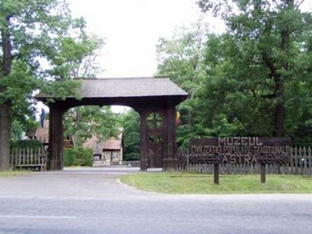
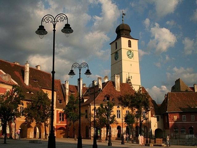
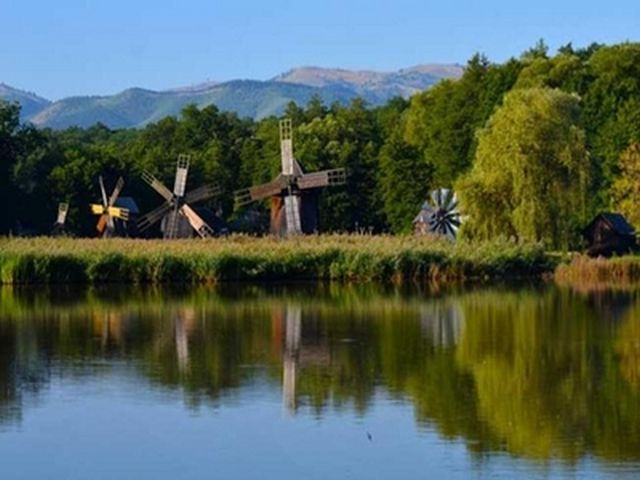
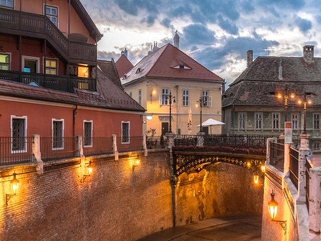
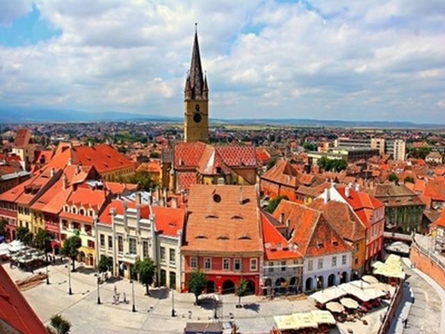
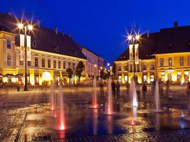
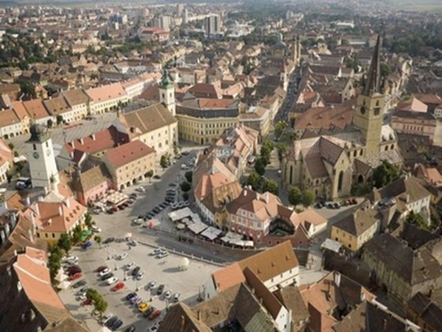
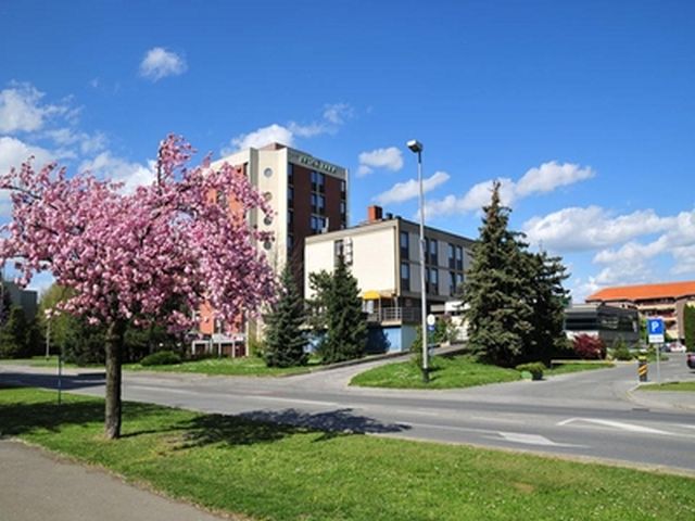
Sibiu is a city in Transylvania, Romania, with a population of 147,245 inhabitants. Located some 215 km north-west of Bucharest, the city straddles the Cibin River, a tributary of the river Olt. Now the capital of Sibiu County, between 1692 and 1791 and 1849–65 Sibiu was the capital of the Principality of Transylvania. Sibiu is one of the most important cultural centres of Romania and was designated the European Capital of Culture for the year 2007, along with the city of Luxembourg. Formerly the centre of the Transylvanian Saxons, the old city of Sibiu was ranked as "Europe's 8th-most idyllic place to live" by Forbes in 2008. The city administers the Păltiniș ski resort. Sibiu is situated near the geographical center of Romania at 45.792784°N 24.152069°E. Set in the Cibin Depression, the city is about 20 km from the Făgăraș Mountains, 12 km from the Cibin Mountains, and about 15 km from the Lotrului Mountains, which border the depression in its southwestern section. The northern and eastern limits of Sibiu are formed by the Târnavelor Plateau, which descends to the Cibin Valley through Gușteriței Hill. The geographical position of Sibiu makes it one of the most important transportation hubs in Romania with important roads and railway lines passing through it. Sibiu is an important economic hub for Romania, with a high rate of foreign investments. It is also an important hub for the manufacturing of automotive components and houses factories. Other local industries are machine components, textiles, agro-industry, and electrical components. The city has also got Romania's second-largest stock exchange. The main industrial activities of Sibiu take place in two industrial zones located on the outskirts of the city: east industrial zone, alongside the railway to Brașov and Râmnicu Vâlcea and west industrial zone, near the exit to Sebeș, close to the Airport. A commercial zone located in the Șelimbăr commune plays an important role in the economy of Sibiu. It houses a mall and other large retailers. Another factor that plays an important role in the economy of the city is tourism, which has been increasing at a steady rate since 2007. Sibiu has one of the most modern international airports in Romania, with direct connections to Germany, Austria, United Kingdom, Italy and Spain as well as to other Romanian cities. Sibiu is one of Romania's most culturally lively cities. It has 3 theatres and a philharmonic orchestra along with other smaller private theatrical venues and a theatre studio housed by "Lucian Blaga" University. „Radu Stanca" National Theatre is one of the leading Romanian theatres. It has both a Romanian-language and a German-language section, and presents an average of five shows a week. „Gong" Theatre is specialised in puppetry, mime and non-conventional shows for children and teenagers. It also presents shows in both Romanian and German. The State Philharmonic of Sibiu presents weekly classical music concerts, and educational concerts for children and teenagers. The concerts take place in the newly restored Thalia Hall, situated along the old city fortifications. Weekly organ concerts are organised at the Evangelical Cathedral during summers. The Sibiu International Theatre Festival is an annual festival of performing arts. Sibiu's museums are organised around two entities: the Brukenthal National Museum and the ASTRA National Museum Complex. The Brukenthal Museum consists of an Art Gallery and an Old Books Library located inside the Brukenthal Palace, a History Museum located in the old Town Hall building, a Pharmacy Museum located in one of the first apothecary shops in Europe, dating from the 16th century, a Natural History Museum and a Museum of Arms and Hunting Trophies. The ASTRA National Museum Complex focuses on ethnography, and consists of a Traditional Folk Civilisation Museum, a 96-hectare open-air museum located in Dumbrava Forest south of Sibiu, a Universal Ethnography Museum, a Museum of Transylvanian Civilisation and a Museum of Saxon Ethnography and Folk Art. The Dumbrava Natural Park stretches over 960 hectares and it is situated 4 km away from the center of the city in the southwest direction along the road towards Răşinari.
Cristian Potcovel, pupil, "Constantin Noica" Theoretical High School Sibiu
Descrierea orașului Sibiu
Sibiul este un oras în Transilvania, România, cu o populație de 147,245 locuitori. Situat la circa 215 km nord-vest de București, orașul traversează râul Cibin, un afluent al râului Olt. Acum, capitala județului Sibiu, între 1692 și 1791 și 1849-1865 Sibiul a fost capitala Principatului Transilvaniei. Sibiul este unul dintre cele mai importante centre culturale din România și a fost desemnat Capitala Europeană a Culturii în anul 2007, împreună cu orașul Luxemburg. Fost centru al sașilor din Transilvania, orașul vechi al Sibiului a fost clasat în 2008 ca fiind "al 8-lea cel mai idilic loc european". Orașul administrează stațiunea de schi Păltiniș. Sibiul este situat în apropiere de centrul geografic al României la 45.792784 ° N 24.152069 ° E. Amplasat în depresiunea Cibinului, orașul se află la aproximativ 20 km de Munții Făgăraș, la 12 km de Munții Cibinului, și la aproximativ 15 km de Munții Lotrului, care mărginesc depresiunea în secțiunea de sud-vest. Limitele de nord și est ale Sibiului sunt formate de Podișul Târnavelor, care coboară spre Valea Cibinului, prin Dealul Gușteriței. Poziția geografică face Sibiul unul dintre cele mai importante noduri de transport din România, cu importante drumuri și linii de cale ferată care trec prin el. Sibiul este un centru economic important pentru România, cu o rată ridicată a investițiilor străine. Este, de asemenea, un nod important pentru fabricarea de componente auto și fabrici de case. Alte industrii locale sunt componente de mașini, textile, agro-industrie, precum și componente electrice. Orașul are de asemenea, a doua cea mai mare bursă de valori din România. Principalele activități industriale ale Sibiului au loc în două zone industriale situate la periferia orașului: zona industrială est, alături de calea ferată spre Brașov și Râmnicu Vâlcea și o zonă industrială de vest, în apropiere de ieșirea spre Sebeș, aproape de aeroport. O zonă comercială situată în comuna Șelimbăr joacă un rol important în economia Sibiului. Acesta găzduiește un mall si alti retaileri mari. Un alt factor care joacă un rol important în economia orașului este turismul, care a crescut într-un ritm constant din 2007. Sibiul are unul dintre cele mai moderne aeroporturi internaționale din România, cu legături directe spre Germania, Austria, Marea Britanie, Italia și Spania, precum și în alte orașe din România. Sibiul este unul dintre orasele cele mai pline de viață culturală din România. Acesta are 3 teatre și o orchestră filarmonică alături de alte locuri de teatru private mai mici și un studio de teatru găzduit de Universitatea "Lucian Blaga". Teatrul National "Radu Stanca" este unul dintre cele mai importante teatre din România. El are atât o secție de limba română cât și o secție de limba germană, și prezintă o medie de cinci spectacole pe săptămână. Teatrul "Gong" este specializat în marionete, mimă și spectacole non-convenționale pentru copii și adolescenți. De asemenea, prezintă spectacole în română și germană. Filarmonica de Stat Sibiu prezintă concerte săptămânale de muzică clasică, concerte educative pentru copii și adolescenți. Concertele au loc în Sala Thalia recent restaurată, situată de-a lungul fortificațiilor orașului vechi. Concerte de orgă săptămânale sunt organizate la Catedrala Evanghelică în timpul verii. Festivalul Internațional de Teatru de la Sibiu este un festival anual de artă interpretativă. Muzeele Sibiului sunt organizate în jurul a două entități: Muzeul Național Brukenthal și Complexul Național Muzeal ASTRA. Muzeul Brukenthal conține-o Galerie de Artă și o Bibliotecă de Cărți Vechi în interiorul Palatului Brukenthal, un Muzeu de Istorie situat în vechea clădire a Primăriei, un Muzeu Farmaceutic situat într-una dintre primele spițerii din Europa, datând din secolul al 16-lea, Muzeul de Istorie Naturală și Muzeul de Arme și Trofee de Vânătoare. Complexul Național Muzeal ASTRA se concentrează pe etnografie, și constă într-un Muzeu al Civilizației Populare Tradiționale, un muzeu cu 96 de hectare în aer liber situat in Padurea Dumbrava, în partea sudică a Sibiului, Muzeul Etnografiei Universale, un Muzeu al Civilizației Transilvaniei și Muzeul de Etnografie și Artă Populara Săsească. Parcul Natural Dumbrava se întinde pe 960 de hectare și este situat la 4 km distanță de centrul orașului, în direcția de sud-vest de-a lungul drumului spre Rășinari.
Fabiana Tâlvan, elevă, Liceul Teoretic "Constantin Noica" Sibiu
Rio Maior and Its Inhabitants
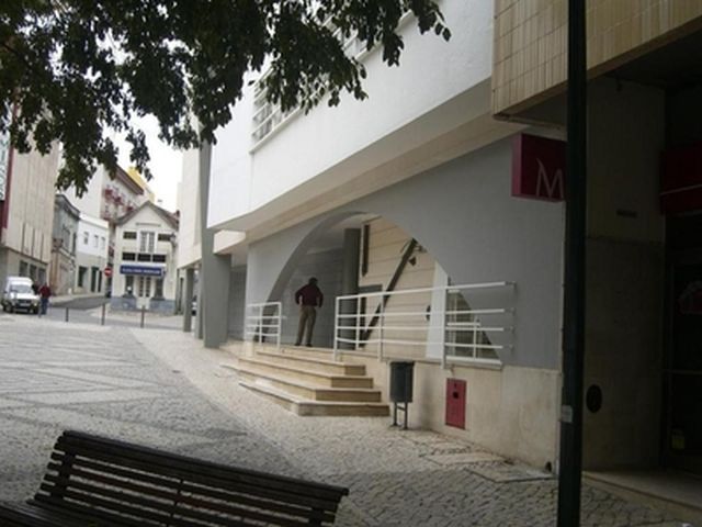
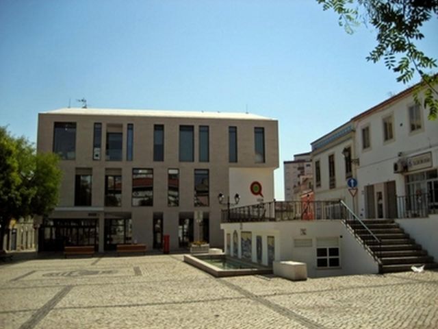
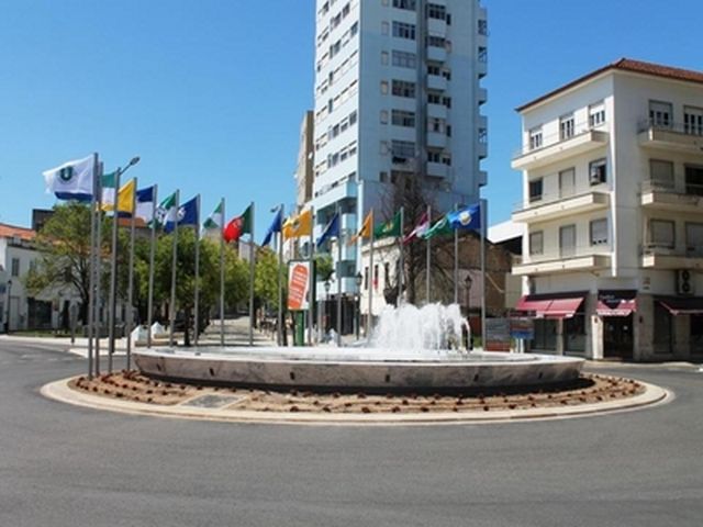
Rio Maior is a Portuguese city belonging to the District of Santarém, with about 8,000 inhabitants. It is soothes of a municipality with 272,76 km ² of area and 21 192 inhabitants (2011), subdivided in 10 parishes. The municipality is limited to the north by the municipality of Porto de Mós, to the northeast and to the south by Santarém, to the south by Azambuja, to the west by Cadaval and by Caldas da Rainha and to the northwest by Alcobaça. Since 2002, Rio Maior has been part of the Alentejo statistical region (NUTS II) and the statistical sub-region (NUTS III) of Lezíria do Tejo; Continues to be part of the Regional Coordination and Development Commission of Lisbon and Tagus Valley, which maintained the designation of the former NUTS II with the same name. It still belongs to the old province of Ribatejo, nowadays but without any political-administrative meaning, but constant in the discourses of self and hetero-identification. 3 km from the city of Rio Maior you can find the natural salt mines of Rio Maior. Rio Maior is known as the city of Sports because, despite its small size, it has vast and award-winning sports infrastructures (sports complex ranked 3rd in the IOC / IAKS AWARD 2007 international competition) and three clubs with some projection. The Rio Maior Sports Union, which has only Football as its modality, the Rio Maior Swimming Club, which has the most prominent swimming and athletics modalities, of which Susana Feitor is a member, and also has the merit of being one of the Portuguese athletes who take more athletes to the Olympic Games (athletes mostly in the discipline of the Athletics March, but also with Olympic swimmers), which also gives name to the Athletics track of the Municipal Stadium and the House of the People of Rio Maior. There is a former club in the city, which in recent years has taken Judo to the highest national and international levels, where the athlete Yahima Ramirez is currently the most renowned judoka. Rio Maior bet heavily on sports facilities, having a well-equipped sports park, which is part of the modern Internship Center and Olympic Swimming Pool, but is still very unused in local terms.
Anabela Brigida, Erasmus+ school coordinator, Agrupamento de Escolas Fernando Casimiro Pereira da Silva
Rio Maior e seus habitantes
Rio Maior é uma cidade portuguesa pertencente ao Distrito de Santarém, com cerca de 8 000 habitantes. É sede de um município com 272,76 km² de área e 21 192 habitantes (2011), subdividido em 10 freguesias. O município é limitado a norte pelo município de Porto de Mós, a nordeste e a sul por Santarém, a sul pela Azambuja, a oeste pelo Cadaval e pelas Caldas da Rainha e a noroeste por Alcobaça. Desde 2002 que Rio Maior integra a região estatística (NUTS II) do Alentejo e na sub-região estatística (NUTS III) da Lezíria do Tejo; continua, no entanto, a fazer parte da Comissão de Coordenação e Desenvolvimento Regional de Lisboa e Vale do Tejo, que manteve a designação da antiga NUTS II com o mesmo nome. Pertencia ainda à antiga província do Ribatejo, hoje porém sem qualquer significado político-administrativo, mas constante nos discursos de auto e hetero-identificação. A 3 km da cidade de Rio Maior pode encontrar as Salinas naturais de Rio Maior. Rio Maior intitula-se a cidade do Desporto, porque apesar do seu pequeno tamanho conta com vastas e premiadas infraestruturas de desporto (complexo desportivo classificado em 3º lugar no concurso internacional IOC/IAKS AWARD 2007) e com três Clubes com alguma projecção. O União Desportiva de Rio Maior, que tem apenas o Futebol como modalidade, o Clube de Natação de Rio Maior, que tem como modalidades mais proeminentes a natação e o atletismo, do qual faz parte Susana Feitor, tendo também o mérito de ser um dos clubes Portugueses que leva mais atletas aos jogos olímpicos (atletas esses maioritariamente da disciplina de Marcha do atletismo, mas também com presenças olímpicas de nadadores), que também dá nome à pista de atletismo do Estádio Municipal e a Casa do Povo de Rio Maior o mais antigo clube da cidade, que tem nos últimos anos levado o Judo aos mais altos patamares nacionais e internacionais, onde a atleta Yahima Ramirez é actualmente a judoca de maior projecção. Rio Maior apostou forte nas instalações desportivas, possuindo um bem equipado parque desportivo, do qual faz parte o moderno Centro de Estágios e a Piscina Olímpica, estando no entanto muito desaproveitado em termos locais.
Célia Pereira, professor, Agrupamento de Escolas Fernando Casimiro Pereira da Silva
Paphos City
Paphos is a city in the southwestern part of Cyprus, the capital of the homonymous province and one of the most important ancient kingdoms of the island. Among other things, it was famous as a center of worship of the goddess Aphrodite. The city is divided into two levels: the upper Paphos, known as Land which is the commercial center of the town and Kato Paphos where is lower and beach and is the foremost tourist destination of the island. All the archaeological site of Paphos is under UNESCO protection since 1980. The city's name is associated with the goddess Venus, because Paphos was the name of the mythological daughter of Aphrodite and Pygmalion. Apollodorus the Athenian mentions Kinyras founder of Paphos' Kinyras in Cyprus paragenomenos plus Pafon built among the people. And he Loutatios, considers Paphos, son of Kinyras, as founder of the city, although in Isidore, Paphos Paphos built by the son of hurricanes. Also Pausanias and Homer mentioned as founder of Paphos and Palepaphos the Agapinor, king of Tegea Arcadia that after returning from the Trojan War founded Palepaphos, current Kouklia. Great interest is shown by the settlement Maa - Paleokastro that bears much in common with other Mycenaean buildings - forts. Cypriot kingdoms are known that dissolved at the end of the 4th century by Ptolemy I, one of the successors of Alexander the Great. Shortly before that the last king of Paphos, the Nikoklis, had moved the seat of the kingdom of the west, in a more appropriate location, which was named Nea Pafos (Kato Paphos today). Nea Pafos was to meet brilliant glory days during the Hellenistic period, as the seat of the governors of Cyprus, which was included in the kingdom of the Ptolemies, the Greek kings of Egypt. The great cultural legacy of the city and the region of Paphos nearly 4000 years of existence, became Paphos essentially a large open museum. For this reason, UNESCO simply added the whole town on the World Heritage List. Real treasure considered the mosaics that were found after excavations in Kato Paphos, the House of Dionysus, the House of Aion and Theseus house, and which were kept in very good condition beneath the earth for 16 centuries until their accidental discovery in recent years and its disclosure after many years of excavations. In the same area are the Tombs of the Kings, who are believed to be rich cemetery during Roman times. There are tombs dating from the 4th century, also the column of St. Paul, where the apostle was tortured and flogged by "forty but one" as punishment for the introduction of a "new daemons' the place in missionary activity. In the same area are located below the surface of the earth the catacombs of St. Solomoni and Agios, Lamprianou which became the first religious ceremonies by Christians when persecuted. The first fact, that of Agia Solomoni preserved frescoes. Also in the area of the mosaics are three theaters of which kept only two, the most famous of which is the "Ancient Odeon» Paphos. This Roman Odeon which is used today for performances also survived near Ancient Odeon part of Paphos walls ruins of the Roman Forum as the Asklepieion. More modern monuments like the castle "Forty Columns" remnant of the era of the Lusignan, like Paphos trademark, the famous castle located at Paphos harbor and was built to protect the harbor from Raiders originally by the Byzantines and after the Lusignan in the 13th century. All the above were incorporated into an archaeological park, which covers the area from the harbor up to the Kings tombs, accessible only to pedestrians, and even today many missions from various foreign universities arrive in the area for excavation after a very small percentage of fully excavated. In 2017 he voted as Europe's cultural capital of course not accidental, because of the wide cultural heritage.
Demetris Symeonides, Erasmus+ school coordinator, Gymnasium Apostolou Paulou in Paphos
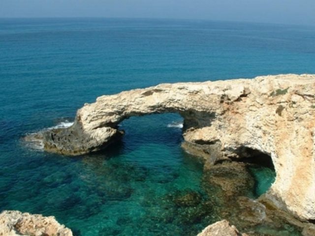
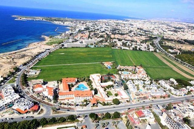
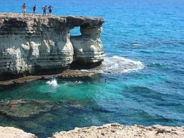
Η Πάφος Πόλη
Η Πάφος είναι πόλη στο νοτιοδυτικό τμήμα της Κύπρου, πρωτεύουσα της ομώνυμης επαρχίας και ένα από τα πιο σημαντικά αρχαία βασίλεια της νήσου. Μεταξύ άλλων, ήταν διάσημο και ως κέντρο λατρείας της θεάς Αφροδίτης. Η πόλη χωρίζεται σε δύο επίπεδα: Στην πάνω Πάφο, γνωστή και ως Κτήμα που είναι το εμπορικό κέντρο της πόλης και την Κάτω Πάφο πού βρίσκεται χαμηλότερα και παραλιακά και είναι ο κατ' εξοχήν τουριστικός προορισμός του νησιού. Όλος ο αρχαιολογικός χώρος της Πάφου βρίσκεται υπό την προστασία της UNESCO από το 1980. Το όνομα της πόλης συνδέεται με τη θεά Αφροδίτη, δεδομένου ότι Πάφος ήταν το όνομα της μυθολογικής κόρης της Αφροδίτης και του Πυγμαλίωνα. Ο Απολλόδωρος ο Αθηναίος αναφέρει τον Κινύρα ως ιδρυτή της Πάφου «Κινύρας εν Κύπρω παραγενόμενος συν λαώ έκτισε Πάφον». Ο δε Λουτάτιος, θεωρεί τον Πάφο, γιο του Κινύρα, ως θεμελιωτή της Πόλης, αν και κατά τον Ισίδωρο, την Πάφο έκτισε ο Πάφος, γιος του Τυφώνος. Επίσης ο Παυσανίας και ο Όμηρος αναφέρουν σαν ιδρυτή της Πάφου και της Παλαίπαφου τον Αγαπήνορα, Αρκάδα Βασιλιά της Τεγέας που μετά την επιστροφή του από τον Τρωικό πόλεμο ίδρυσε την Παλαίπαφο, τα σημερινά Κούκλια. Μεγάλο ενδιαφέρον δείχνει και ο οικισμός Μαα - Παλαιόκαστρο που φέρει πολλά κοινά με άλλα μυκηναϊκά κτίσματα - οχυρά. Τα κυπριακά βασίλεια είναι γνωστό ότι διαλύθηκαν κατά τα τέλη του 4ου π.Χ. αιώνα από τον Πτολεμαίο Α', έναν από τους διαδόχους του Μεγάλου Αλεξάνδρου. Λίγο πιο πριν ο τελευταίος βασιλιάς της Πάφου, ο Νικοκλής, είχε μεταφέρει την έδρα του βασιλείου του δυτικότερα, σε πιο κατάλληλη τοποθεσία, που ονομάσθηκε Νέα Πάφος (η σημερινή Κάτω Πάφος). Η Νέα Πάφος έμελλε να γνωρίσει λαμπρές ημέρες δόξας κατά τα ελληνιστικ χρόνια, ως έδρα των κυβερνητών της Κύπρου, η οποία και είχε ενταχθεί στο βασίλειο των Πτολεμαίων, των Ελλήνων βασιλέων της Αιγύπτου. Η πολύ μεγάλη πολιτιστική κληρονομιά που άφησαν στην πόλη και την περιοχή της Πάφου τα 4000 σχεδόν χρόνια ύπαρξής της, κατέστησαν την Πάφο ουσιαστικά ένα μεγάλο, ανοικτό μουσείο. Για αυτό τον λόγο η UNESCO πρόσθεσε απλά ολόκληρη την πόλη στον κατάλογο παγκόσμιας πολιτιστικής κληρονομιάς της. Πραγματικός θησαυρός θεωρούνται τα ψηφιδωτά που ανευρέθησαν μετά από ανασκαφές στην Κάτω Πάφο, στην Οικία του Διονύσου, την Οικία του Αιώνος και την Οικία του Θησέως, και τα οποία διατηρήθηκαν σε πάρα πολύ καλή κατάσταση κάτω από την γη για 16 αιώνες μέχρι την τυχαία ανακάλυψή τους στα τελευταία χρόνια και αποκάλυψή τους μετά από πολλών χρόνων ανασκαφές. Στην ίδια περιοχή βρίσκονται και οι Τάφοι των Βασιλέων, που πιστεύεται ότι αποτελούν νεκροταφείο πλούσιων κατά την Ρωμαϊκή εποχή. Οι τάφοι χρονολογούνται από τον 4ο αιώνα. Επίσης η στήλη του Αποστόλου Παύλου, οπού ο Απόστολος βασανίστηκε και μαστιγώθηκε με «σαράντα παρά μία» ως τιμωρία για την εισαγωγή «καινών δαιμονίων» στον τόπο κατά την Ιεραποστολική του δράση. Στην ίδια περιοχή βρίσκονται, κάτω από την επιφάνεια της γης οι κατακόμβες της Αγίας Σολομωνής και του Αγ. Λαμπριανού όπου γίνονταν οι πρώτες θρησκευτικές τελετές από τους Χριστιανούς όταν διώκονταν. Στην πρώτη μάλιστα, αυτή της Αγίας Σολομωνής σώζονται και τοιχογραφίες. Επίσης στην ευρύτερη περιοχή των ψηφιδωτών βρίσκονται και τρία αρχαία θέατρα από τα οποία διατηρούνται μόνο τα δύο, το γνωστότερο από τα οποία είναι το «Αρχαίο Ωδείο» της Πάφου. Πρόκειται για ρωμαϊκό ωδείο το οποίο χρησιμοποιείται και σήμερα για παραστάσεις. Σώζονται επίσης κοντά στο Αρχαίο Ωδείο μέρος των τειχών της Πάφου, χαλάσματα της Ρωμαϊκής Αγοράς όπως και του Ασκληπιείου. Πιο σύγχρονα μνημεία όπως το κάστρο «Σαράντα Κολώνες» απόμεινάρι της εποχής των Λουζινιανών, όπως και το σήμα κατατεθέν της Πάφου, το περίφημο κάστρο που βρίσκεται στο λιμανάκι της Πάφου και είχε κτιστεί για προστασία του λιμανιού από επιδρομείς αρχικά από τους Βυζαντινούς, και έπειτα από τους Λουζινιανούς τον 13ο αιώνα. Όλα τα πιο πάνω εντάχθηκαν σε ένα αρχαιολογικό πάρκο, που καλύπτει την περιοχή από το λιμάνι της πόλης μέχρι και τους τάφους των Βασιλέων, προσβάσιμο μόνο από πεζούς, ενώ ακόμα και σήμερα πολλές αποστολές από διάφορα πανεπιστήμια του εξωτερικού καταφθάνουν στην περιοχή για ανασκαφές αφού ένα πολύ μικρό ποσοστό της έχει ανασκαφεί πλήρως. Το 2017 ψηφίστηκε ως πολιτισμική πρωτεύουσα της Ευρώπης φυσικά όχι τυχαία, λόγω της ευρείας πολιτισμικής της κληρονομιάς.
Maria Theofanous-Anthi, διευθυντής σχολείου , Gymnasium Apostolou Paulou in Paphos
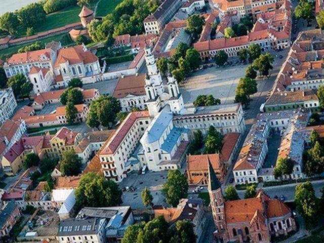
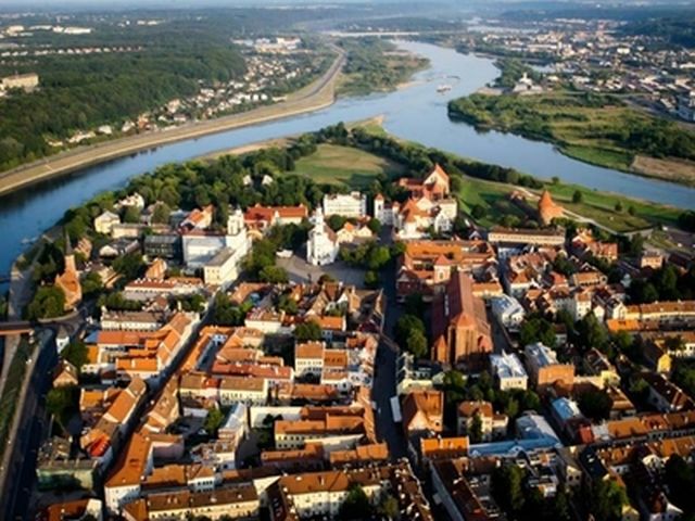
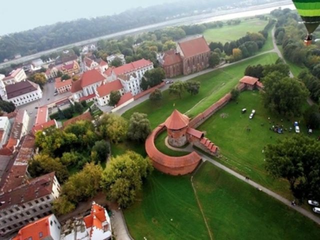
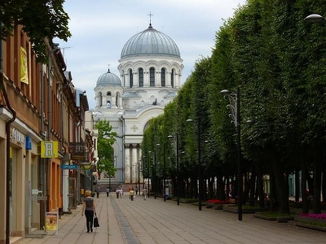
Kaunas City
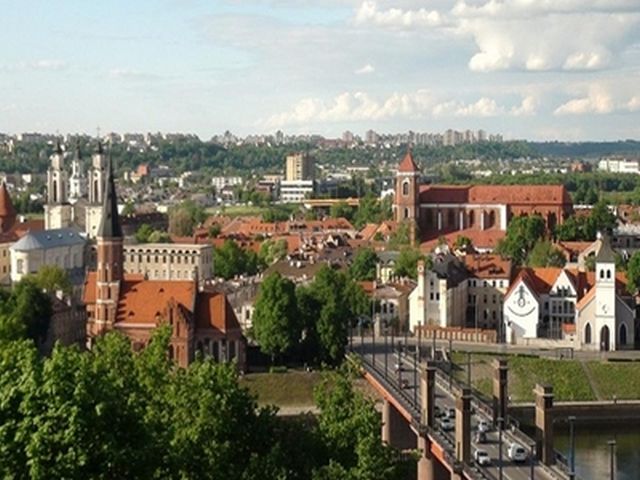
Kaunas is Lithuania's second largest city in the central part of the country, the Nemunas and the Neris, an important industrial, transport, scientific and cultural center, the Provisional Capital. Kaunas City Municipality, Kaunas District, the Archdiocese center. Kaunas have about 70-80 m above sea level. The highest point in the city of Fort IX (100.1 m), the lowest - riverbed at Lampedziai. The central part of the city is among the Neman and Neris rivers, lowland, 30-35 m above sea level, surrounded by three - Žaliakalnis, Aleksoto and Silainiu hills. The city has a continental climate, the coldest - January, the hottest - the month of July. During the year, knocked about 630 millimeters of precipitation. The prevailing southwest winds. The town has many protected areas, nature reserves, which are found in the Red Book of Lithuania recorded the animals. The most beautiful city parks - Ąžuolynas, Pažaislis and Panemunė sila. Key Kaunas of pollution are transport, industry and energy companies. Drinking water is used to prepare the ground and surface water, extracted four city waterworks. In 2008, on 16 September, Marvelė entry into service of a modern biological waste water treatment plants. The purified water meets the requirements of the European Union. The oldest part of the city of Kaunas - Kaunas Old Town, which has formed a rectangular street plan. Since 1847, Forming a new type of tsarist times rectangular structure started systematic Kaunas new town buildings. Gradually, the old part of Kaunas started to connect the adjacent densely populated areas. New Town with Liberty Avenue is considered to be the current city center. In 1889, to Kaunas city was connected Zaliakalnis, distinguished private home, the main street Vydūnas alley. City further expanded in 1919, connecting ALEKSOTO and Vilijampolė and 1932 and Sanco, about 1960. The city is also owned and Freda, Petrašiūnai, Panemune. All other areas have been developed and connected to Kaunas until around 1980, and the current limits of the city acquired in 1996. Currently, there are 32 parts of the city (residential and industrial areas). Parts of the city are still divided into smaller units - urban areas.
Rita Rasikiene, headmaster, President Valdas Adamkus gymnasium Kaunas
Kaunas Miestas
Kaunas yra antrasis pagal dydį Lietuvos miestas šalies centrinėje dalyje, Nemuno ir Neries santakoje, svarbus pramonės, transporto, mokslo ir kultūros centras, Laikinoji sostinė. Kauno miesto savivaldybės, Kauno rajono savivaldybės, arkivyskupijos centras. Miestas yra beveik pačiame Lietuvos centre, Lietuvos Vidurio žemumoje, išsidėstęs didžiausių šalies upių Nemuno ir Neries santakoje. Prieš miestą, užtvenkus Nemuną, suformuotos Kauno marios. Kitoje Miesto pusėje telkšo Lampėdžio ežeras. Kaunas iškilęs apie 70–80 m virš jūros lygio. Aukščiausias miesto taškas yra IX forte (100,1 m), žemiausias – Nemuno vagoje ties Lampėdžiais. Miesto centrinė dalis yra tarp Nemuno ir Neries upių, žemumoje, 30–35 m aukštyje virš jūros lygio, apsupta trijų – Žaliakalnio, Aleksoto ir Šilainių kalvų. Miesto klimatas žemyninis, šalčiausias – sausio, šilčiausias – liepos mėnuo. Per metus iškrenta apie 630 milimetrų kritulių. Vyrauja pietvakarių krypties vėjai. Mieste yra daug saugomų teritorijų, draustinių, kuriuose aptinkami į Lietuvos raudonąją knygą įrašyti gyvūnai. Gražiausi mieste parkai – Ąžuolynas, Pažaislio ir Panemunės šilai. Pagrindiniai Kaune aplinkos teršėjai yra transportas, pramonės ir energetikos įmonės. Geriamajam vandeniui paruošti naudojamas gruntinis ir paviršinis vanduo, išgaunamas keturiose miesto vandenvietėse. 2008 m. rugsėjo 16 d. Marvelėje pradėti eksploatuoti modernūs biologinio nuotekų valymo įrenginiai. Išvalytas vanduo atitinka Europos Sąjungos reikalavimus. Seniausioji Kauno miesto dalis - Kauno senamiestis, kuriame susiformavo stačiakampis gatvių planas. Nuo 1847 m., suformavus naują carinio laikų tipo stačiakampę struktūrą, pradėtas planingas Kauno naujamiesčio užstatymas. Palaipsniui prie senosios Kauno dalies imta prijungti gretimas tankiai apgyvendintas teritorijas. Naujamiestis su Laisvės alėja yra laikomas dabartiniu miesto centru. 1889 m. prie Kauno miesto prijungtas Žaliakalnis, išsiskiriantis privačiais namais, pagrindinė gatvė Vydūno alėja. Miestas dar labiau išsiplėtė 1919 m. prijungus Aleksotą ir Vilijampolę, o 1932 m. ir Šančius. Apie 1960 m. miestui taip pat priklausė ir Freda, Petrašiūnai, Panemunė. Visi kiti rajonai buvo išplėtoti ir prijungti prie Kauno maždaug iki 1980 m., o dabartines ribas miestas įgavo 1996 m. Šiuo metu yra 32 miesto dalys (gyvenamieji ir pramoniniai rajonai). Miesto dalys dar yra skirstomos į smulkesnius vienetus - miesto teritorijas.
Vita Kuliešiūtė, mokytojas, President Valdas Adamkus gymnasium Kaunas
Čakovec City
Čakovec is a city in northern Croatia, at around 90 kilometres (56 miles) north of Zagreb, the Croatian capital. Čakovec is both Međimurje County’s seat and the largest city, the northest, smallest and densely populated Croatian county. The adjacent villages of Belica, Nedelišće, Pribislavec, Strahoninec and Šenkovec are seats of separate municipalities, although they're located within 5 km (3 mi) of the city's centre. The total population of the city's metropolitan area, with all aforementioned villages is about 45,000. At the 2001 census, Čakovec City had a population of 15,790 within its limits, a slight decrease from the 1991 census, when it was 15,999. Including its surrounding suburbs, it had a population of 30,455 at the 2001 census. The city's present day population has ethnic Croats at 93.8%, with the largest minority being Romani at 3.8% of the municipality. Other ethnic groups are Serbs, Hungarians, Slovenes and Albanians. According to the geographer Strabo's reports in the 1st century, Čakovec today's location was Aquama site (wet town) in Roman times and at the time a marshland, a military post and a legionnaire camp. The name Čakovec comes from the ispán Csák Hahót’s first name. With the 13th century start he erected the timber fortification. later named Csák's tower, (Croatian: Čakov toranj). It was first mentioned in 1328 and the place appeared in the official books in 1333. From 1350 to 1397, it was in Lacković’s House possession. The period of more significant economic and cultural growth of Čakovec is considered to have started in 1547, when Nikola Šubić Zrinski of Szigetvár became the owner of the area. At that time the castle was lavishly decorated, surrounded by a park and sculptures of famous army leaders and monarchs. Duke Juraj IV Zrinski granted privileges to the inhabitants of the Čakovec fortress and its suburbs on 29 May 1579. This was the starting point for Čakovec to become a free market town and the date is celebrated today as "City Day". The Čakovec Castle which was owned by the House of Zrinski between the 16th and the 18th century is known today as the "Zrinski Old Town" (Stari grad Zrinskih) and is considered the main landmark of the city. It is located in the Zrinski Park (Perivoj Zrinskih) only a few steps from the central square. In 1738 the city was devastated by an earthquake, in 1741 by a large fire, and another earthquake hit it in 1880. At the end of the 18th century, the owners of the town became counts from the House of Feštetić, and the town was turned into a big estate where industry, crafts and trade developed. In 1848 the ban Josip Jelačić captured Čakovec from the Hungarians and joined it with Croatia. The first railroad track was built here in 1860 and to help connect Budapest with the ports of Rijeka and Trieste. The town was connected by railroad with Mursko Središće and Lendava in 1889 and in 1893 electricity was introduced. Čakovec was the seat of a district (Hungarian: járás) in Zala county of the Kingdom of Hungary until 1918. It again became part of Hungary between 1941-44 during World War II, until it was captured on the 6 April 1945 by the Soviet Red Army with Marshal Fyodor Tolbukhin in command. In the late 1990s and throughout the 2000s several modern buildings were built and opened to the public. In 1999 a brand new bathing resort including four indoor swimming pools and a jacuzzi was opened as a part of the city's center for sports and recreation. In 2003 a renovated sports hall, originally built in the 1970s and belonging to the constructional high school, was also opened as a part of the center for sports and recreation and hosted several group matches of the 2003 World Women's Handball Championship. Beginning in the late 1990s and early 2000s several large shopping centers and automobile showrooms emerged in the city, mostly in its northwestern part. Čakovec was twice rewarded The Green Flower award for the tidiest continental city in Croatia, in 2008 and 2009. Čakovec is the first city of the former Yugoslavia to have installed completely electronic information spots, located at the Republic Square and the Franciscan Square in the Center and at the Square of Saint Anthony of Padua in the Jug district. The city opened its new university called MEV - Međimursko veleučilište u Čakovcu (University of Međimurje in Čakovec). In the last decade the city has developed into one of 10 cities with the highest GDP in Croatia. Čakovec is known as the city of traffic circles, because, during the late 1990s and early 2000s, all of its traffic lights in the inner part of the city were removed and replaced with traffic circles or rotaries, virtually eliminating traffic jams. The only remaining traffic lights in the city are located on the southern bypass. Although Čakovec is a small city by global parameters, its large working force which comes from all over the county, its location and importance in the region caused many traffic jams on the crossroads. Čakovec is home for many famous Croatian punk bands, including Bakterije and Motorno Ulje.
Ivana Ružić, Erasmus+ school coordinator, l. osnovna skola Cakovec
Čakovec Grad
Čakovec je grad u sjevernoj Hrvatskoj, koji se nalazi oko 90 km (56 milja) sjeverno od Zagreba, glavnog grada Hrvatske. Čakovec je i sjedište županije i najveći grad u Međimurju, najsjevernijoj, najmanji i najnaseljeniji hrvatske županije. Susjedna sela Belica, Nedelišće, Pribislavec, Strahoninec i Šenkovec sjedišta su zasebne općine, iako su svi smješteni unutar 5 km (3 MI) od gradskog središta. Ukupan broj stanovnika u gradu gradsko područje, sa svim gore navedenim selima je oko 45.000. Na popisu iz 2001. godine, grad Čakovec je imao populaciju od 15,790 unutar svojih granica, što je neznatno smanjenje u odnosu na popis stanovništva iz 1991. godine, kada je bilo 15.999. Uz okolna predgrađa uključena je imao populaciju od 30,455 po popisu stanovništva iz 2001. godine. Gradsko današnja populacija uglavnom sastoji od etničkih Hrvata na 93,8%, a najveći manjine bude Romani na 3,8% u općini. Ostale etničke skupine su Srbi, Mađari, Slovenci i Albanci. Prema geograf Strabon je izvješća u 1. stoljeću, današnja lokacija grada Čakovca bio je mjesto Aquama (mokri grad) u rimsko doba, u to vrijeme u močvare, vojna pošta i legionar logor. Ime Čakovec dolazi iz prvog imena ispán Csák Hahót. S početkom 13. stoljeća podigao drvenu utvrdu koja je kasnije nazvana Csak kula (hrvatski: Čakov toranj). Spominje se prvi put 1328., a mjesto se pojavila u službenim knjigama u 1333. Od 1350. do 1397., bio je u posjedu doma Lacković. Razdoblje značajnijeg ekonomskog i kulturnog rasta Čakovca Smatra se da je započeo u 1547, kada je Nikola Šubić Zrinski od Szigetvár postao vlasnik tog područja. U to vrijeme, dvorac je bio bogato ukrašen, okružen parkom i skulpturama čuvenih vojskovođa i vladara. Vojvoda Juraj IV Zrinski privilegije stanovnicima u Čakovcu tvrđave i okolnih naselja 29. svibnja 1579. To je bila polazna točka za Čakovec postati slobodan trgovački grad, a datum se danas obilježava kao "City Day". Dvorac Čakovec koji je u vlasništvu Doma Zrinski između 16. i 18. stoljeća je danas poznato kao "Zrinski Stari grad" (Stari grad Zrinskih) i smatra glavni simbol grada. Nalazi se u Perivoj Zrinskih (Perivoj Zrinskih), samo nekoliko koraka od središnjeg trga. U 1738. grad je razoren u potresu, u 1741 od strane velikog požara, a još jedan potres pogodio je 1880. Krajem 18. stoljeća vlasnici grada postao broji od doma Feštetić, a grad je pretvorio u velikog imanja na kojem se susreću, obrtništvo i trgovina razvila. Godine 1848. ban Josip Jelačić zarobljeni Čakovec od Mađara i pridružio se s Hrvatskom. Prva željeznička pruga sagrađena je ovdje u 1860, a kako bi se povezali Budimpeštu s lukama Rijeka i Trst. Grad je povezan željeznicom s Mursko Središće i Lendava 1889. i 1893. uvodi se struja. Čakovec je sjedište okruga (mađarski: járás) u Zala županiji Kraljevine Ugarske do 1918. Ponovno je postao dio Mađarske između 1941-44 tijekom Drugog svjetskog rata, dok je bio zarobljen na 6. travnja 1945. sovjetska Crvena armija s maršalom Fjodora Tolbukhin u naredbu. U kasnim 1990-ih i tijekom 2000-ih nekoliko modernih zgrada izgrađena i otvorena za javnost. Godine 1999. potpuno novi kupalište uključujući i četiri unutarnja bazena i jacuzzi otvoren je kao dio gradskog centra za sport i rekreaciju. Godine 2003. obnovljena sportska dvorana, prvobitno izgrađena u 1970 i pripadnosti građevinskom srednje škole, također je otvorena u sklopu Centra za sport i rekreaciju, a domaćin je nekoliko grupnih utakmica na svijetu Ženske 2003 rukometnog prvenstva. Počevši u kasnim 1990-ih i ranih 2000-ih nekoliko velikih trgovačkih centara i auto saloni pojavile u gradu, uglavnom u njegovom sjeverozapadnom dijelu. Čakovec je dva puta nagrađen ZELENI CVIJET nagradu za najurednija kontinentalnog grada u Hrvatskoj, u 2008. i 2009. godini Čakovec je prvi grad u bivšoj Jugoslaviji imati instaliran potpuno elektroničke informacijske točke, koji se nalazi na Trgu Republike i franjevački trg u središtu i na trgu svetog Antuna Padovanskog u četvrti Jug. Grad je otvorio svoj novi sveučilišni zove MeV - Međimursko Veleučilište u Čakovcu (Sveučilište u Međimurju u Čakovcu). U posljednjih desetak godina grad se razvio u jednu od 10 gradova s najvećim BDP-a u Hrvatskoj. Čakovec je poznat kao grad prometnim krugovima, jer je, tijekom kasnih 1990-ih i ranih 2000-ih, sve njegove semafora u unutarnjem dijelu grada su uklonjena i zamijenjena s prometnim krugovima ili rotaries, gotovo uklanjanje prometne gužve. Jedini preostali semafori u gradu se nalaze na južnoj obilaznici. Iako Čakovec je mali grad globalnih parametara, po velikoj radnoj snazi koja dolazi iz svih krajeva županije, njegov položaj i značaj u regiji izazvao mnoge prometne gužve na raskrižju. Čakovec je dom za mnoge poznate hrvatske punk bendova, uključujući Bakterije i Motorno ulje.
Draženka Blažeka, učitelj, l. osnovna skola Cakovec